Woodlands and Napier Parks Walking Trail (Essendon)

The 4.1km walk begins at the park's Carnarvon Road entrance. Woodlands Park, with its large lake and landscaped island, provides habitat for many small animals, birds and local ducks.
Difficulty: Easy
Surface: Concrete, gravel, grass
Limited wheelchair access: Access can be gained at Woodlands Park. Sections of the track are gravel and grass and may prove difficult for people in wheelchairs.
Bus information: For bus information on the return journey see map or 'getting home again' section.
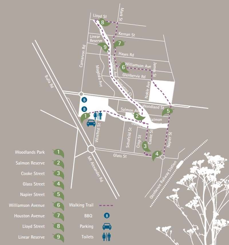
Woodlands and Napier Parks Walking Trail Map

Woodlands and Napier Parks Walking Trail Notes
1 Woodlands Park
Recent replanting of native vegetation in the lake has helped to improve water quality and allowed natural ecosystems to establish. Rumour has it that the lake also houses a very healthy yabby population. The park, reserved for public recreation in 1883, is a wonderful location for social get-togethers, or simply to enjoy its relaxing atmosphere. Facilities include a cottage, rotunda, footbridge over the lake, BBQ area and playground equipment, which make it an ideal place for a picnic.
Continue along the path past the ornamental lake with its majestic palm trees, then veer off to the right of the fork, crossing Schofield Road and continuing on to Salmon Reserve.
2 Salmon Reserve
Salmon Reserve was a gift from William F. Salmon of Roseneath in Woodlands Street to the people of the City of Essendon, made in 1918. He was a tree enthusiast who planted many of the now mature exotic trees in Salmon Reserve. As you are walking along the track watch for Cooke Street on your right midway through Salmon Reserve.
Turn right into Cooke Street.
3 Cooke Street
Cooke Street was named after Bernard Cooke, the licensee of the Lincolnshire Arms Hotel in Lincoln Road, who was a shire councillor in the 1860s.
Turn left into Glass Street.
4 Glass Street
Glass Street was named after pastoralist Hugh Glass, one of the richest men in the colony during the 1850s. The owner of Flemington House, later known as 'Travancore', Mr Glass also owned 107 acres of land running west along Buckley Street to Waverley Street.
Turn left into Napier Street.
5 Napier Street
Napier Street is named after Thomas Napier, who settled in the area in 1849. In 1920, his son Theodore Napier offered the City of Essendon nine and half acres of land on the condition that the land be free of development, be given to the local community as picnic grounds and that all the trees were protected. The park was originally called Northern Park, and remained so until 1959. The major feature of Napier Park is the magnificent River Red Gums. These trees sometimes provide nesting for native fauna, which include possums, brown falcons, cockatoos and wood ducks. All of these animals can be found at Napier Park. The Koorie People who originally inhabited the area also had many uses for the Red Gums. Its timber and bark were used to make canoes, containers and clubs, while sap from the tree was used for medicinal purposes. Take a walk through this beautiful reserve.
Once you have come to the end, keep walking straight into James Street and continue until you reach Williamson Avenue, then turn left.
6 Williamson Avenue
Many of the streets in this area were named after prominent early residents of the area. James Street is believed to be named after Thomas Napier's father. Williamson Avenue is named after a Broadmeadows Shire President who owned a farm in the Glenroy area in the early 1900s.
When this street comes to an end, turn right into Houston Avenue.
7 Houston Avenue
Follow Houston Avenue until it ends at Kernan Street John Kernan was a farmer who lived near here in the 1860s. Cross Kernan Street and continue along Marks Street to Lloyd Street. Turn left into Lloyd Street.
8 Lloyd Street
Near the end of Lloyd Street, you will reach a very narrow park.
Turn left at the park. Stay alert! It is very easy to miss the park.
9 Linear Reserve
This park follows a dry creek bed that used to flow to meet five Mile Creek near Woodlands Park. Five Mile Creek flows from Woodlands Park to join Moonee Ponds Creek near Moreland Road.
Follow the reserve crossing five streets until you return to Salmon Reserve.
Location
Cnr Carnarvon Road and Bulla Road Service Road, Essendon 3040 View Map
Web Links
→ Woodlands and Napier Parks Walking Trail Brochure (PDF)


