Wonthaggi - Victorian Desalination Project Ecological Reserve Trails

There are a number of walks (6-8km / 2-3 hours) in the 225 hectare ecological reserve surrounding the Desalination Plant. The walks cover natural and restored bushland, wetlands and dunes, and include two viewing decks, a bird hide and picnic area.

The trails, which are compacted gravel and boardwalks, are easy with some moderate to difficult undulations depending on the track.
Map of Desalination Project Ecological Reserve with Discovery Points
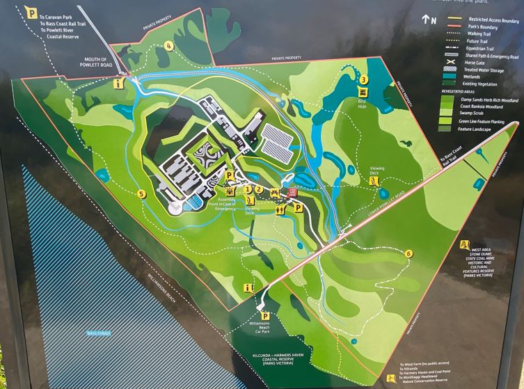
Look for the discovery points throughout the Victorian Desalination Plant and ecological reserve to learn about the desalination process, the history of the Bunurong/Boon wurrung people, uses of this land since settlement, the green roof and the complexities of the revegetation process undertaken here. At the wetland you will find a bird hide to new some of the diverse birdlife of this coastal region.
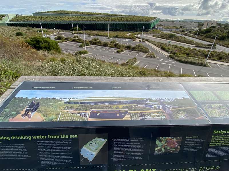
1. Plant viewing deck / Making drinking water from the sea
Look out over the reverse osmosis building and learn about the process of desalination and how the vast green roof is working for the environment.
2. Landscape viewing deck / Restoring ecosystems
Enjoy the view over land restored to the subtle mosaic of complex ecosystems that existed here prior to its being cleared for farming and mining.
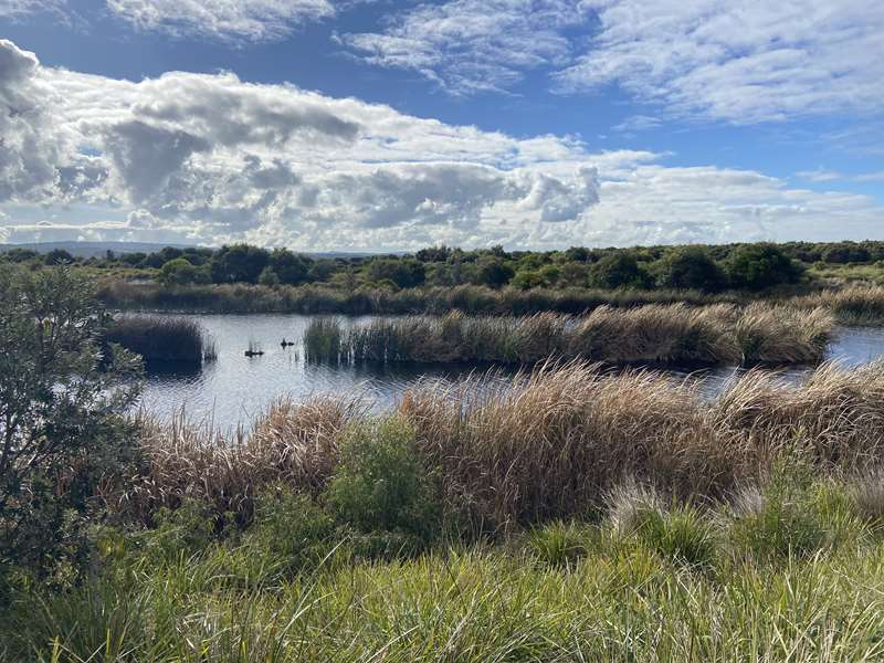
3. Bird hide / Birds, frogs, fish and skinks
From a quiet bird hide, discover the rich diversity of life thriving in the restored wetlands.
4. Indigenous history/ The Bunurong/Boon wurrung people of the Kuhn nation
Learn about the Bunurong/Boon wurrung, their uses of the land and the effects of European settlement.
5. The dunes/ Natural dunes and constructed dunes
See how the ecological reserve uses constructed dunes to rehabilitate the foreshore and blend the Victorian Desalination Plant into the landscape.
6. Using the land
Cows, coal, wind, water and trees. This land has seen many uses since European settlement. Each use has both marked the land and served our needs in its own way.
Cows - Grazing cleared bushland and introduced weeds and the pasture grasses needed to produce the dairy products we consider important. The dairy industry here gave way to the coal industry, only to return again once the coal industry left.
Coal - Coal was first discovered here in 1852 by Richard Davies, and was mined by the Victorian Coal Company. Difficulties transporting the coal soon forced the mine's closure. In 1909 the State Coal Mine opened and for 59 years extracted over 16 million tonnes of coal from 12 separate mines, working mostly thin seams less than 3 metres thick. This energy source helped power Victoria's railways and build Victorian Industry, and brought the skills, institutions and infrastructure that established Wonthaggi as a regional centre. An elaborate network of tunnels remains. and the 'Stone Dump' mullock heap and remnants of heavy machinery can still be seen.
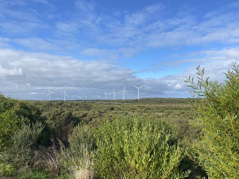
Wind - Recently the energy industry has returned to Wonthaggi. The Wonthaggi Wind Farm was built in 2005 and its six turbines produce 12MW of electricity, enough to power 6000 homes. A commitment to offset the power used during the desalination process at the Victorian Desalination Plant is driving investment in wind farms such as the one you can see here.
Water and trees The site is now a source of rainfall independent water. The Victorian Desalination Plant is capable of producing up to 150 billion litres of water a year. The ecological reserve restores the environmental damage of previous land uses and creates a place for everyone to enjoy.
Access for Dogs:
Dogs are not permitted.
Making drinking water from the sea
Desalination removes salts and minerals from seawater so it is like pure rain water before it runs over rocks and through rivers. Millions of people in Australia and around the world drink and use desalinated water every day. The water is so pure minerals must then be added for it to meet Australian Drinking Water Guidelines and Victorian health requirements. The high quality water produced by the Victorian Desalination Plant complements Melbourne's existing supplies.
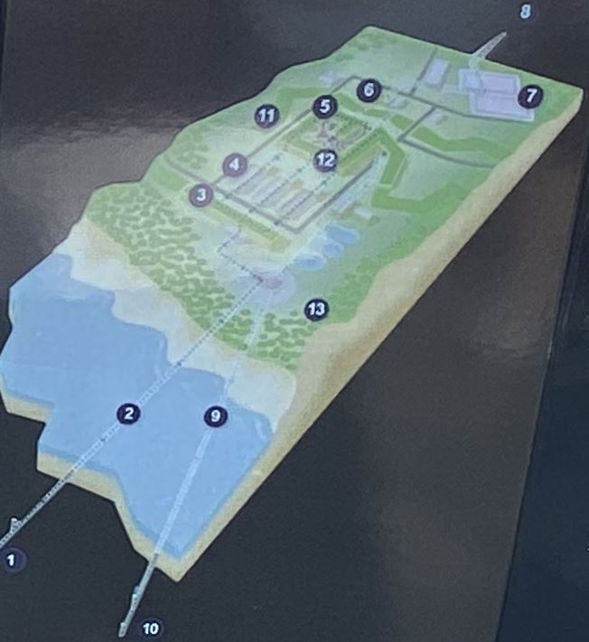
1. Specially designed intake structures very slowly draw in ocean water. Even small fish can swim against the intake current. Larger marine life is protected from the intake by a special grille
2. A 1.2 kilometre-long pipeline brings the ocean water to the filters in the Screen and Feed Building. The pipeline runs beneath the seabed to protect the marine environment.
3. In the Screen and Feed Building the water is filtered to remove fine particles.
4. Water is filtered a second time in the Dual Media Pressure Filter (DMPF) Building to remove solids such as any remaining sand and sediment.
5. The filtered water is pushed through an ultra-fine membrane at extremely high pressures of up to 1000psi, close to 30 times an average car tyre This is called 'reverse osmosis'.
6. The desalinated water is remineralised, to meet Australian Drinking Water Guidelines and Victorian health requirements.
7. The water is stored before being distributed.
8. An 84 km underground pipeline delivers desalinated water to regional areas through direct offtakes, if required, and to Cardinia Reservoir where it can be distributed across Melbourne The pipeline is two-way so it can also transfer water from Cardinia Reservoir to regional areas.
9. A 1.5 kilometre-long pipeline that runs beneath the seabed carries the filtered seawater concentrate back to the ocean.
10. Diffusers return the filtered seawater concentrate back to the ocean and it is quickly diluted by ocean currents.
Design minimising impacts
By reducing visual impact and noise, creating habitat, cleaning and retaining water before it enters the Rowlett River and acting as insulation, the green roof is working for the environment.
Thanks in a large part to the green roof, the reverse osmosis building is barely visible from Kilcunda, the Bass Coast Rail Trail and the Bass Highway. The green roof has been carefully designed by landscape architects, architects and ecologists to blend the building into the landscape, with vegetation chosen to merge with the vegetated mounds that conceal the majority of the plant structures.
Integrated systems - The systems necessary to support the plant life of the roof are built into the roof structure itself: irrigation and filtering systems, drainage, waterproofing, and the root repellent system. The roof's design had to consider the harsh coastal conditions, and the variations in rainfall and temperature that are characteristic of South Gippsland. The soil is lightweight and its composition is specific for this project. Many plants which are native to the local area and which are able to tolerate the conditions on the green roof are represented here.
Green roofs can be classified as extensive, semi-intensive or intensive depending on the thickness of the planting layer and their maintenance requirements.
Extensive green roofs, such as this one, are designed with very thin soil layers and to be self-sustaining, and are usually only accessed for maintenance.
Green roofs filter pollutants, improve air quality, reduce stormwater runoff, act as insulation, create habitat, increase agricultural space and reduce the urban heat island effect. At the time of construction, this green roof with an area of more than 26,000 m2 (2.6 hectares), is the largest in the southern hemisphere.
Review:
There are two main walking loops. One loop is a wide gravel track south of Lower Powlett Road which passes through dunes and close to wind turbines. This loop can be ridden on horses.
There is another bigger loop which passes around the Desalination plant with a side track to a viewing platform of the plant. The Desalination Plant area can be reached by a road off Lower Powlett Road or via walking tracks. There is a car parking area, toilets, shelter with two tables and water tap.
The tracks are well signposted and there is an occasional map.
Photos:
Location
Lower Powlett Road, Wonthaggi 3995 View Map


