Warrak - Langi Ghiran State Park


Rugged granite peaks and gentle sloping woodlands are the dominant features of this park. A pleasant walk to the mountain summit presents a view of ancient red gums on the surrounding plains skirted by Mount Buangor in the east and the Grampians in the distant west. Lar-ne-jeering (Langi Ghiran) is from the Djab Wurrung language meaning 'home of the black cockatoo'.
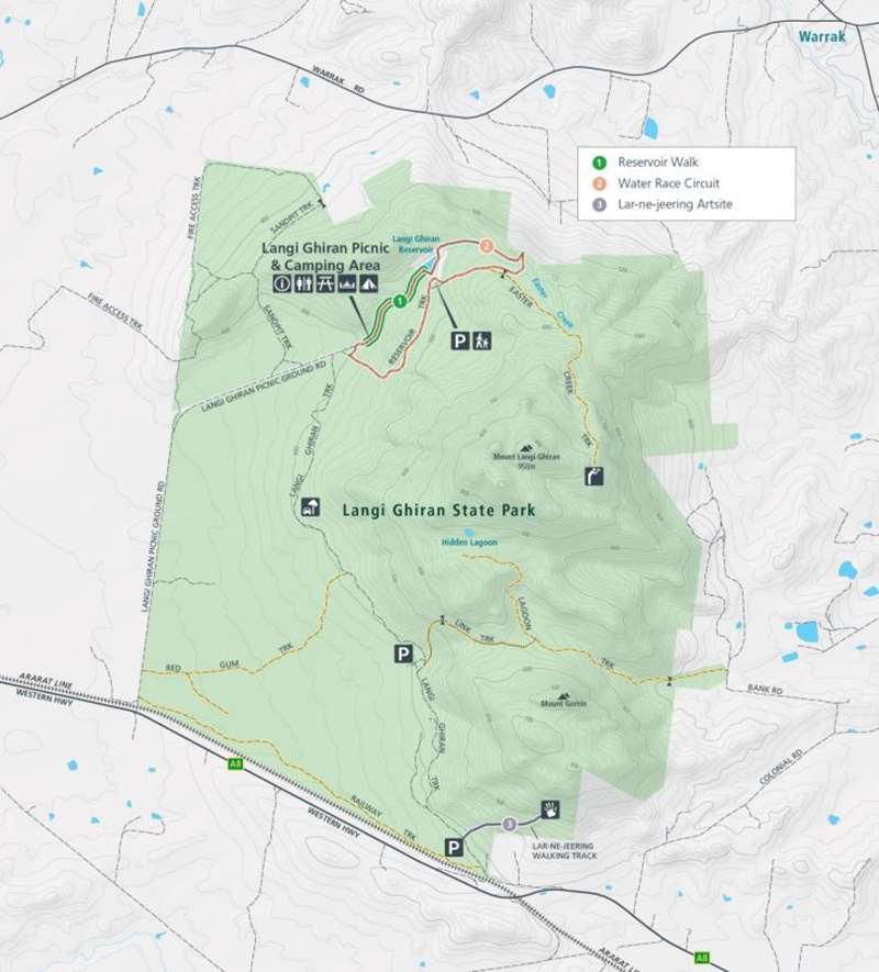
Langi Ghiran State Park Map

Enjoying the Park
Walking
Reservoir Walk - 2.6km, 45 minutes return
Easy grade, some steps and uneven ground.
Starting from the Langi Ghiran picnic ground this gentle walk climbs slowly beside Easter Creek passing by a small dam and weir hewn from local granite. The quality of the stonemason's craftmanship is clearly visible from the walking track.
There are views all the way to the summit as the walk passes large granite bounders, before arriving at the old reservoir, originally constructed in 1880 to supply water for Ararat.
Take care near deep water. Be aware as the reservoir and holding dam are deep and children should always be supervised.
Water-race Circuit - 5.1km, 1.5 hours return
Moderate grade with steps and uneven ground.
Extending from the Reservoir Walk to follow the historic granite water-race this track meanders through the lightly forested lower slopes of the park. Return to the picnic ground via the Reservoir Track to complete this circuit.
Lar-ne-jeering art site - 1.8km, 30 minutes return
Easy grade with some steps and uneven ground.
Unique to this area the Aboriginal rock art site sits within a granite rock shelter. To the Djab Wurrung, this area is a sacred site. As you visit, you can feel a natural peacefulness around you. Try to imagine the spiritual significance that Larne-jeering (Langi Ghiran) has, with its mountain peaks overlooking the landscape created by Bunjil and what is now known as the Western District of Victoria.
Camping and Picnics
There is car-based camping and a small picnic site among Candlebark Gums at the end of Kartuk Road
Driving
A drive along the 6.3km one-way Langi Ghiran Track reveals a variety of vegetation types and landforms. We recommend a slow speed with stops at regular intervals.
History
Major Thomas Mitchell climbed Mt Langi Ghiran on his 1836 expedition through 'Australian Felix. The two reservoirs in the park were built from locally hewn granite blocks in 1880. The main reservoir still forms part of the Ararat water supply and is worth a visit.
Access for Dogs:
Dogs, cats and horses are not permitted in this park.
Location and Access
Located between Ararat and Beaufort on the Western Highway, Route A8.
Note: Photos from Parks Victoria
Location
Langi Ghiran Track, Warrak 3377 Map
Web Links
→ Langi Ghiran State Park (Parks Victoria)
→ Langi Ghiran State Park - Visitor Guide (PDF)


