Warburton Circuit Walk

Wander through the leafy, peaceful back streets of beautiful Warburton and into the bush where the town meets the towering gum trees.
How to get there
Warburton is approximately 35 km along the Warburton Highway east of Lilydale. In the middle of town, turn right up a steep hill towards the Police Station. Take the first driveway on the left and park in the public carpark next to the Police Station. The Tourist Information Centre is in the Waterwheel building.
Facilities
There are public toilets in the middle of town in a small park on the left hand side beyond the playground down towards the river. The town has a number of cafes. There is an ATM at the Warburton Community Bank (Bendigo Bank).
Things to see and do
The Warburton Circuit provides you with the opportunity to walk through the quiet leafy back streets of the Warburton township , get elevated views of the town and into the bush without having to wander too far from town.
Pass via "Boinga Bob's" eclectic house which is a cross between a Tibetan monastery and a Balinese Hotel.
The walk above Old Warburton Rd provides spectacular vistas of the green valley through the towering Mountain Grey gums.
At the bottom of the walk there is a picturesque waterfall in Dolly Grey park. You can sit and eat your lunch or just stop for a break on your way back to the start.
The walk takes approximately two (2) hours for the return trip and is graded at easy-medium. The medium sections are the uphill sections into and out of the State forest above Warburton.
Walk information
Grade: Medium Distance: Approximately 10 km (2 hours)
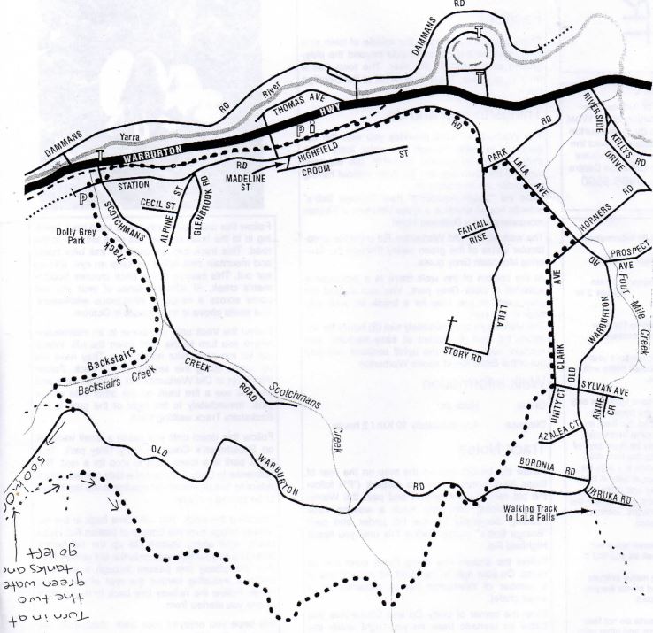
Warburton Circuit Walk Map

Track Notes
Follow the broken line on the map above. From the carpark ("P") follow the old rail way line behind and past the Waterwheel building until you reach a walking track heading diagonally up the hill under and past "Boinga Bob's" house. Follow this until you reach Highfield Rd.
Follow the broken line along these quiet narrow roads. On your right in Highfield Rd you will one of a number of Warburton homes modelled on a Swiss chalet.
From the corner of Unity Crt and Clarke Ave you follow an unmade track on your right under the powerlines and up the hill. Towards the top of this rise the track turns left and back to Old Warburton Rd.
Follow this until you reach a well used track heading in to the bush on your left on a left turn in the road. This track can be used by trail bike riders and mountain bike riders so keep an eye, and an ear out. This section of the track crosses Scotchman's creek. At different times of year, you will come across a range of indigenous wildflowers.
Follow the track until you come to an intersection where you turn to the right down the hill. Watch out for mountain bike riders here. They have set up jumps along this section of the track. Follow this down to Old Warburton Rd. Turn left here and you will see a fire track on the other side with a gate. Immediately to the right of the gate is the Backstairs Track walking track.
Follow this down until you reach a small waterfall on Scotchmen's Creek in Dolly Grey park. This small park is a lovely spot to stop for a rest. The reference to Dolly Grey is not a lady named dolly it refers to "small wheels for moving loads too heavy to be carried by hand".
Following the track you will come back to the old railway bridge over the bottom of Station Rd. Head briefly right along Station Rd up the hill before diverging to your left back onto the old railway line. The old railway line passes through a series of cuttings, including behind the rear of the Alpine Hotel. Follow the railway line back to the carpark where you started from.
Location
44 Station Road, Warburton 3799 Map


