Walhalla - Poverty Point Bridge Walk

Follow the old horse-drawn tramway above the Thomson River to view the historical Poverty Point Bridge built in 1900.
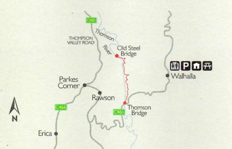
Follow the Thomson River from the Thomson River Bridge (Walhalla Rd) to the Poverty Point Bridge and back. This is a picturesque loop walk where you can walk upstream on one side of the river and return on the other. Keep your eye out for the remains of the old tramways and dry stone walling that once supported the timber tramway from Walhalla.
From: Thomson River Bridge, 4km from Walhalla
Length 6.6km, 3 hours (return)
Facilities: Accommodation, parking, food, drink, toilets and picnic amenities are available.
Surface: Level 1-2. Suitable for most ages and fitness levels. No steps. Gentle hills. Formed track some obstacles. Limited signage. Bushwalking experience recommended.
About this walk
Experience the area's rich gold mining history and immerse yourself in the rugged beauty of the Thomson River and surrounding mountainous valleys with this walk. The area?s dense forest is abundant with wildlife, and in early spring it becomes golden with flowering wattles.
This walk will take you along what used to be a horse-drawn tramway that took timber from the forest to supply the gold-mining town of Walhalla in the late 1800s. At the end of this 6.6km return walk is the heritage listed Poverty Point Bridge, completed in June 1900 as part of this tramway.
The bridge is significant as it was constructed from prefabricated steel supplied by Dorman Long and Co. of Middlesbrough, England. This company is better known for designing and building Sydney Harbour Bridge which was opened decades later in 1932.
From the bridge, return the way you came to complete the walk or continue along the trail which joins up with the Australian Alps Walking Track, a challenging long-distance walk through the High Country and beyond.
How to get there
From the Tyers-Walhalla Rd, head east onto the Walhalla Rd until you reach the Thomson Bridge. As you reach the bridge, head north on Old Depot Rd until you reach the Thomson Campground. The campground provides good parking with a short walk to the trailhead of the Steel Bridge Walking Track. From the campground, continue along Old Depot Rd for approximately 100 meters to reach the start of the walking track.
Poverty Point Bridge Walk Map
Access for Dogs:
Dogs are permitted on leash.
Note: The Poverty Point Bridge is currently closed to pedestrian traffic due to structural concerns.
Location
Thomson River Bridge, Walhalla 3825 Map
Web Links
→ Walhalla Self-Guided Town Walk map
")


")