Nelson and Surrounds Walks

There are a number of lovely walks in the Nelson area with lengths ranging from 2.5km to 15km plus two epic walks, the The Great South West Walk (GSWW) and the 'Aussie Camino' which pass through the area.
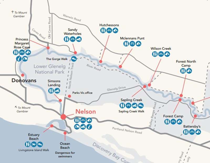
Livingstone Island Walk
2.5km - Easy Difficulty - Est. 1.5hr
Easy loop walk of about 2.5km, commencing from the Estuary Beach car park. The walk takes in views of the Glenelg River, unique marsh areas and offers bird watching opportunities.
- The walk; Start at the western side of the carpark at the end of Beach Road about 3 km from Nelson overlooking the river mouth
- Glenelg River Estuary An ideal habitat for waterbirds. The river was originally explored by Major Mitchell in 1836. He named it after Lord Glenelg Secretary of State for the Colonies.
- Saltmarsh Inundated only by very high tides and is very saline because of evaporation. Many species of plants, including the Beaded Glasswort grow here.
Sapling Creek Walk
4.5km - Easy Difficulty - Est. 1.5hr
An easy loop of 4.5km, commencing from the Sapling Creek picnic area off River Road. Approximately 8km drive from Nelson.
- Follow the Great South West Walking Track along the banks of the Glenelg River. The walk can be shortened if desired by diverting back to the picnic area from Glenelg Drive. Some of the walk is along Glenelg Drive - watch out for vehicles.
- Tree Hollows; homes for a wide variety of wildlife including possums, owls, kookaburras and cuckoos.
- Common Trees; Blackwood, Brown Stringy Bark and Manna Gum.
- Mistletoe; Common throughout the area. A tree parasite to some, but a place to kiss for others!
- Wildlife; Lizards and samll mammals such as the Brown Antechinus or Marsupial Mouse find shelter amongst the forest debris.
The Gorge Walk
10km - Medium Difficulty - Est. 3.5hr
Starts at the car park near the intersection of the North Nelson Track and River Road, this is a 10km walk of medium difficulty, taking in views of the limestone cliffs and wildflowers in season.
- Note - loose sand makes North Nelson River Track suitable for 4 wheel drive vehicles only in dry months. Follow the Great South West Waling Track to the west along the banks of the Glenelg River. At times the track is very close to the limestone cliffs - take care. Picnic facilities are available at the western end of the walk. From here you can either retrace your steps back to the car park or make a loop walk by following the management vehicle track.
- Wildlife; Echidnas leave evidence of their passing by burrowing and turning over soil in search of ants and termites. Water birds such as Black Ducks and Shelducks can be seen on the river.
- Wildflowers; Heath, bush peas, and native orchids such as Helmet Orchids, Spider Orchids, Greenhoods and Sun Orchids.
- Glenelg River Gorge; Limestone made from tiny marine organisms that were part of an ancient sea bed 10 to 25 million years ago.
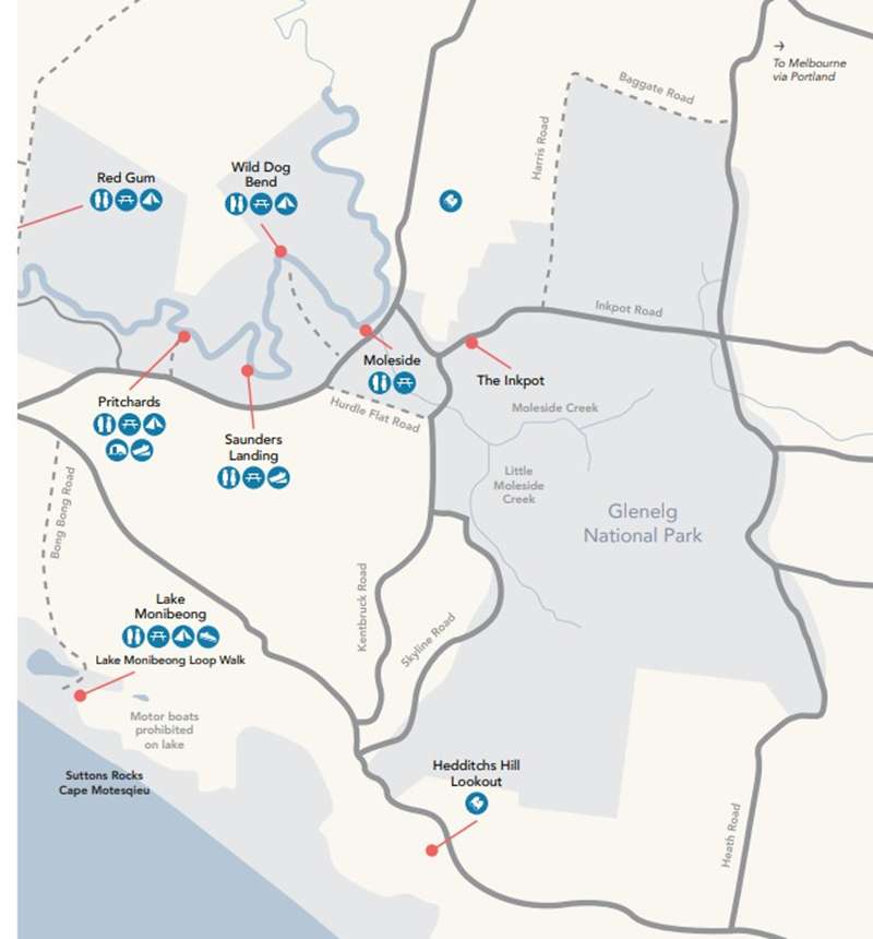
Lake Monibeong Loop Walk
15km - Medium Difficulty - Est. 4.5hr
Starts from campsite five in the Monibeong camp area, this is a 15km loop walk of medium difficulty, the walk passes the southern shore of the lake, heading for Nobles Rocks, return along the beach, turning off at Cape Montesquieu - Suttons Rocks.
- The walk; Start from campsite No. 5 in the Monibeong camping area, at the end of the road Lake Monibeong Road branches south from the main Portland- Nelson Road about 16 km from Nelson. The walk passes the southern shore of the lake heading for Nobles Rocks. At the car park return along the beach, turning off at Cape Montesquieu to get back to Lake Monibeong.
- An ideal spot to view water birds. The lake supports many native fish species such as Pigmy Perch, Galaxias and River Blackfish.
- Nobles Rocks Middens. Shells such as Pipis, Whelks and Mussels accumulated on the rocks. They are the remains of meals eaten by Aboriginal people up to several thousand years ago. You may also see small pieces of flint, chipped away when hand tools were made.
- Cape Montesquieu Headland. Made of layers of compacted sand. Built up over thousands of years. these layers also contain the remains of Calcified tree roots and ?solution tubes? made by the percolating water.
Great South West Walk
250km - Hard Difficulty - Est. 12 day walk (entire loop)
The Great South West Walk (GSWW) is a bushwalking trail suitable for most ages and abilities comprising of short walks, full-day walks, or for the courageous, the whole 250km loop. The track begins in Portland and traverses through the forest, following the Glenelg River downstream through the town of Nelson, before returning along the coastline back to Portland.
This world-class experience includes four unique walking environments that have been divided up into the Forest Walk, the Glenelg River Gorge walk, the Discovery Bay Beach walk and the Capes and Bays walk.
The trail winds around tall hardwood forests, the pristine Glenelg River, aboriginal cultural sites, the mighty Southern Ocean with vast sand dunes, sandy bays and beaches, rugged cliffs, freshwater lakes, and a diversity of natural fauna and flora. See the large breeding colony of fur seals, lose yourself in the enchanted forest, walk its rugged cliffs, take in its sublime bays, breathe in its tranquil forests and be in awe of the pristine river.
'Aussie Camino'
176km - Hard Difficulty - Est. 11 day walk
The 'Aussie Camino' celebrates the spirit and traditions of Spain's 1,200 year-old Camino de Santiago. The trail begins in Portland, Victoria and finishes in Penola, South Australia.
")


")