Nagambie - Explorers Way Driving Tour

The Explorer's Way driving trail incorporates the journeys of Hume and Hovell in 1824 and Major Mitchell in 1836 through Strathbogie Shire.
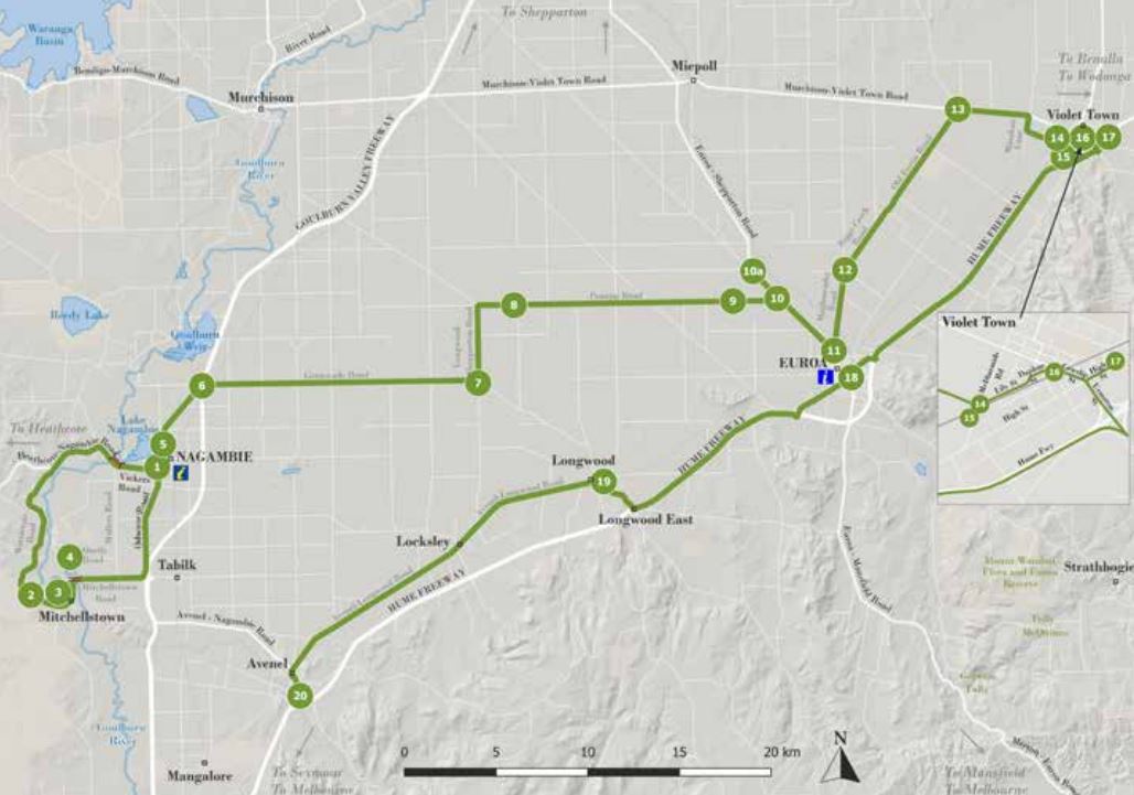
Explorers Way Driving Tour Map

Finding new pastures - Hamilton Hume and William Hovell
The drive from Violet Town to Avenel follows, in reverse, the steps of Hume and Hovell as they returned home to Sydney in December 1824.
Their party consisted of themselves and six other men. With fruitless searches for passes through mountain ranges and struggles to cross deep rivers without boats, they continued on their way south through the Port Phillip District in search of good pasture, eventually arriving at Corio Bay, which, incidentally, they thought was Westernport. This miscalculation delayed Port Phillip District settlement for a decade, as when a party was sent by ship to Westernport to establish a settlement, it was found not only to be unsuitable, but to have been wrongly identified.
Their homeward trek avoided the more mountainous country by staying further west, crossing the Goulburn River at Tallarook, before heading North East close to today's Avenel, Longwood, Euroa and Violet Town. This road eventually became known as the Sydney Road, then the old Hume Highway.
Finding Australia Felix
On October 9,1836, Major Thomas Mitchell cut a large blaze in a tree and buried instructions under ground marked with a deeply cut cross, on the banks of the Goulburn River not far from the present Mitchellstown cairn.
He and his advance party of 14 men then crossed the river and camped on the other side before hastening on to return to Sydney. This became known for years as The Crossing Place or Old Crossing Place. His instructions were for his second in command, Granville Stapylton.
The two surveyors, a Wiradjuri guide - John Piper, and 23 convicts, had begun the Australia Felix expedition in February 1836, which had crossed the Port Phillip District of New South Wales from the Murray to Portland, with 70 animals pulling laden carts and covered wagons, including a boat wagon with two boats. They were now returning to Sydney. Some of the animals had perished and vehicles were lost in swamps. They returned through the Grampians, past Mount Macedon to cross the present Goulburn River and continue north past the Nagambie lagoon, bearing north east at Wahring, towards present day Euroa and Violet Town. Mitchell surveyed the track which is now encompassed by the Strathbogie Shire. Deep ruts left by the boat carriage could be seen for years and, known as the Major's Line, proved to be the first route south for overlanders.
This section of the drive is part of the Major Mitchell Bicentennial Trail of 1988 which followed their tracks through Victoria as closely as possible using existing roads.
1. Nagambie Township

Start your journey in the picturesque town of Nagambie 90km north of Melbourne, off the Goulburn Valley Freeway. Stop for a coffee at one of the many cafes and enjoy the view over Lake Nagambie. Wander through the Museum and follow a Heritage Trail through the town, available from the Visitor Information Centre.
2. Major Mitchell Memorial Cairn
- Mitchellstown Road
Turn off High Street at the petrol station, onto Vickers Road. Travel over Chinaman's Bridge and keep left to take Wattlevale Road. After passing Major Creek Camping Reserve, keep an eye out for the Major Mitchell Cairn marking his camp site in 1836, on the left.
3. Mitchelton Winery
- Mitchellstown Road
Continue to follow Wattlevale / Mitchellstown Roads until you reach the impressive entrance to the iconic Mitchelton Winery. At the end of the main drive, as you turn into the winery, is a large rock with a plaque marking the first postal route to the Port Phillip District of New South Wales, c1838, which then became the old Port Phillip Road. Do not miss this impressive modern winery with the iconic Robin Boyd / Ted Ashton Tower, Indigenous Art Gallery, Cellar Door, the Muse Restaurant and beautiful lawns on the banks of the Goulburn River.
4. Tahbilk Winery
-254 O'Neils Road
Turn left out of the gates at Mitchelton Winery and over the bridge. Turn left into Mullers Road then left again into O'Neils Road and follow the signs to Tahbilk Winery. Another worthwhile stop, take time to visit the historic Cellar Door and wander the wetlands on the Eco Trail. Refreshments available at the Wetlands Caf?. Leave Tahbilk via the Nagambie exit, just past the Wetlands Caf? and take the back road into Nagambie through the rolling pastures and impressive thoroughbred studs.
5. Major Mitchell Cairn
- High Street Nagambie
In the centre of Nagambie on the median strip is a large bluestone cairn commemorating Major Mitchell's passage nearby in 1836.
6. Grimwade Road
Head north out of town and take the overpass onto Grimwade Road heading towards Longwood. Continue on Grimwade Road for around 30km, and then turn left onto the Longwood-Shepparton Road.
7. Longwood Shepparton Road
Travel 4.2km and turn right onto Pranjip Road.
8. / 9. Major Mitchell over night camp site
- Pranjip Road
As you cross the Castle Creek Bridge, pause for a moment and enjoy the serenity of this idyllic spot where the Major Mitchell troop spent the night in 1836.
10. Arcadia Two Chain Road/ Euroa-Shepparton Road
Continue on Pranjip Road. At the T intersection turn left at the VLine bus stop. Rest a while on the rusty chairs provided for waiting passengers.
10a. Historical Marker
A short distance on the right is a historical marker noting Major Mitchell's route. After the visit return back towards Euroa.
11. Moglonemby Road
Turn left into Moglonemby Road
12. Riggs Creek Road
Turn right into Riggs Creek Road
13. Old Euroa Road Keep right onto Old Euroa Road, then turn right onto Murchison-Violet Town Road. Turn right onto Minahan Lane then left into Alan McDiarmids Road.
14. McDiarmids Road
Just across the railway line on the right is the Southern Aurora Memorial.
15. Southern Aurora Crash Site Memorial
- Meniarmids Road Bail Crossing
Visit the site and wander the boards telling the story of this fatal crash in 1969, Return to McDiarmids Road and travel back over the railway line then right into Lily Street towards Violet Town. Take a right into Daphne Street and then right into Cowslip Street.
16. Southern Aurora Memorial Gardens

- Cowslip Street, Violet
A lovely spot to stop and visit and reflect on what this town went through in 1969. While you are in town wander the main street and visit the Art Gallery & Museum and have a coffee in the cafe.
17. Major Mitchell and Hume & Hovell Cairns
- High Street, Violet Town
Head along Cowslip Street towards the freeway and turn right into High Street. Just outside the entrance to the Honeysuckle Caravan Park is where the explorers intersect on their journeys. Here you will find a cairn to Hume and Hovell and a separate cairn for Major Mitchell, This is as far north as we go. From here, head back to the Hume Freeway towards Euroa, taking Exit 17.
18. Hume & Hovell Cairn
- Burtons Bridge, Euroa
Just over the Burtons Bridge, on Templeton Street, is a Hume and Hovell cairn. Stay and wander though this historic town. Visit the VC Memorial in Kirkland Avenue and Telegraph Park in Brock Street to learn about the military heritage of the town and region. Pick up a heritage walking map from the Euroa Hub at 50 Binney Street. Now we return to the Hume Freeway and head to Longwood, taking the second exit.
19. VC Memorial Tree and Cairn
- Pub Paddock, Down Street, Longwood
The Pub Paddock (behind the White Hart Hotel) is a delightful stop on this journey, with picnic facilities and a toilet. Here you can sit beside the tree planted in honour of Major Tubb VC, one of the three men from the district that were awarded a Victoria Cross.
From here turn left onto the Avenel-Longwood Road and head towards our last stop at Avenel.
20. Hume and Hovell Cairn

- Livingstone Street, Avenel
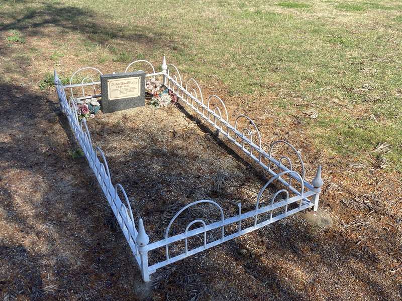
When you arrive in Avenel, keep left and don't cross the railway line. Turn left at the Cemetery (look out for Red Kelly's grave - Ned's dad, beside the road) and meander around Jubilee Park. Just before the T intersection, on the right opposite the pub, hidden under trees, is a memorial to the explorers, specifically Hume and Hovell.
Web Links
→ Explorers Way Brochure (PDF)


