Allambee - Mount Worth State Park


Situated on the western rim of the Strzelecki Ranges, Mount Worth State Park encompasses 1,040 hectares of Mountain Ash forest and regenerating native bush.
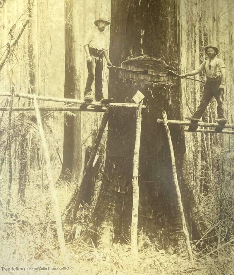
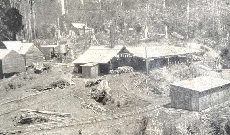
Mount Worth State Park now represents a peaceful and relaxed setting but this hasn't always been the case. During the 1920s, the forests echoed to the sounds of axes, breakdown saws and mill boilers. Between the 1920s and 1940s, up to twelve timber mills operated on the slopes around Mount Worth, stripping the hills of their valuable timber. Today the mills and most of the tall timber are gone although relics of this industry can still be found scattered throughout the Park. Whilst you explore the mill sites, imagine the area bustling with horse teams, timber workers and their families.
A haven for plants and animals
Mount Worth State Park protects 1040 hectares of land including wet sclerophyll forest and former farmlands. The term sclerophyll refers to plants such as eucalypts with hard leaves adapted to reducing moisture loss.
Here you find some classic Victorian forest settings with stands of Mountain Ash rising out of an undergrowth of Tree-ferns. Tall wet forests of Mountain Ash, Mountain Grey Gum and Blackwood grow on the hills and slopes. Soft Tree-ferns and Rough Tree-ferns flourish within the sheltered gullies. The cool moist conditions support a number of rare plants including Netted Brake, Slender Tree-fern and Skirted Tree-fern.
Epiphytes grow on the branches of other plants and take their moisture and nutrients from the wind and rain.
Birdlife is abundant within the park. Superb Lyrebirds scratch amongst the leaf litter, while the forest canopy provides food and nesting areas for a wide range of birdlife. Species found here include the Crimson Rosella King Parrot. Olive Whistler, Eastern Spinebill, Grey Butcherbird, Tawny Frogmouth and the rare Sooty Owl.
The park is also home to the Common Wombat, Swamp Wallaby, Brush-tailed and Ring-tailed Possum, Feathertail Glider, Sugar Glider, Brown Antechinus and Platypus.
Mount Worth is the only area of protected public land which is home to the Giant Gippsland Earthworm. At around 80cm long and 2crn thick, this is one of the world's largest earthworms. It is listed as a threatened species under Victoria's Flora and Fauna Guarantee Act (1988) and is of international conservation significance.
Timber mills and tramways
In 1923, the Allambee Sawmilling Company established a small mill on Larkin Creek. Initially timber was carted by horse drawn wagons, but due to the poor condition of the local roads, a wooden rail tramway and incline were constructed.
A tramway also ran from the mill for 1.2km further into the forest. Logs were winched to the landing and loaded onto trucks where gravity carried them down to the mill on the tramway.
Early in 1924 the plant was sold to J.T. Trevorrow and Sons - a Melbourne engineering firm. They rebuilt the tramway and replaced the mill and winch boiler.
Twenty workers were employed in the mill and in the surrounding forest cutting timber. Most lived in makeshift huts neighbouring the mill, although some enjoyed the comfort of the boarding house run by the wife of a local farmer.
Although badly damaged by bushfire in 1926, the tramway was quickly rebuilt. The mill and tramway finally closed in December 1927 when the nearby timber resources were exhausted.
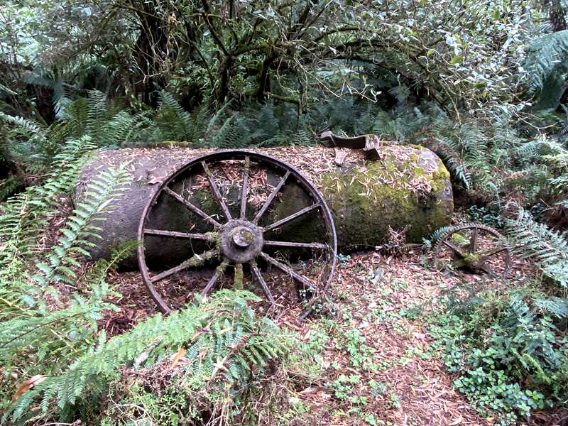
Today the forest has almost reclaimed the site. All that remains of the mill is the sawdust heap, mill boiler and rusting sawmilling equipment hidden amongst the undergrowth.
Things to See and Do
Walking
Map of Mount Worth State Park Walks
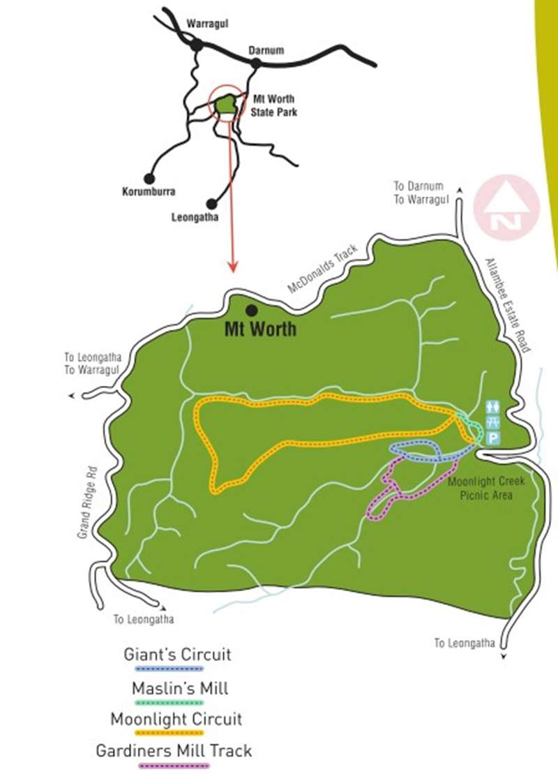
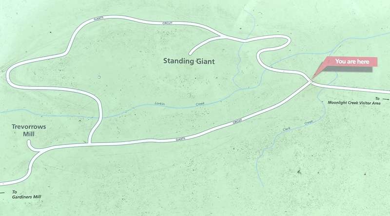
1. Giant's Circuit - 1.8km, 1 hour return
Begin at the Moonlight Creek picnic area and follow the route of a timber tramway through Mountain Ash Forest and fern filled gullies. This lovely walk includes the impressive Standing Giant, a huge Mountain ash with a girth of 7 metres and probably 300 years old.
2. Moonlight Circuit - 8.5km, 3 hours return
Begin at the Moonlight Creek picnic area. This walk combines Moonlight Creek Track and Moonlight Divide Track to form a circuit. It is a strenuous walk suitable for more experienced walkers. The Moonlight Divide Track climbs steeply to the ridge and leads through regenerating Mountain Ash forest with a dense understorey of Dogwood, Daisy Bush and Blackwood. Moonlight Creek Track follows a trickling mountain stream through lush fern gullies, to the sites of old timber mills.
Note: For much of the year the Moonlight Creek Track can be muddy and potentially slippery. Additionally, there are some sections that are difficult to negotiate. This track is recommended for experienced and well-prepared walkers only.
3. Gardiners Mill Track - 1.5km one way, 1 hour return
This walk is an extension of the Giant Circuit and takes you through regenerating Mountain Ash forest and along the tree-fern lined Clark Creek.
4. Maslin's Mill - 800m one way, 40 minutes return

Commencing at the far end of the Moonlight Creek picnic area this track meanders through forest of Mountain Ash and Blackwood to Maslin's Mill site. Suitable for people with limited mobility. Just north of the Moonlight Creek picnic area the track divides. Take the right track (Moonlight Creek Track)
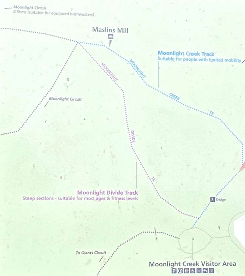
The track meanders through Mountain Ash forest following the Moonlight Creek. It is suitable for people with limited mobility.
Maslin's sawmill operated on this site from 1928 to 1932. Timber was an important industry for the region but most settlers saw it only as a means of clearing the land for farming. Selling their timber or working in the sawmills provided them with a source of income while they were establishing their farms.
Various types of farming were tried including dairying, sheep, pigs and potatoes, but many farmers struggled to make a living. Getting their produce to town was a major problem depriving families of an income and sending some bankrupt. Muddy tracks were often impassable leaving farmers isolated for months at a time. Small acreages, steep slopes, infertile soil and unreliable income forced many off their farms. This area became known as the "Heartbreak Hills".
A short distance beyond Maslin's Mill, the track joins with the Moonlight Divide track.
If uneven ground is not a problem, you may choose to return by following the Moonlight Divide track back to the car park (approximately 1 km). Alternatively, you can return the way you have come.
As you go around the walk, listen for the sound of the Superb Lyrebird mimicking the calls of other birds. You may hear the distinctive call of the Eastern Whipbird or spot the bright red plumage of a Crimson Rosella.
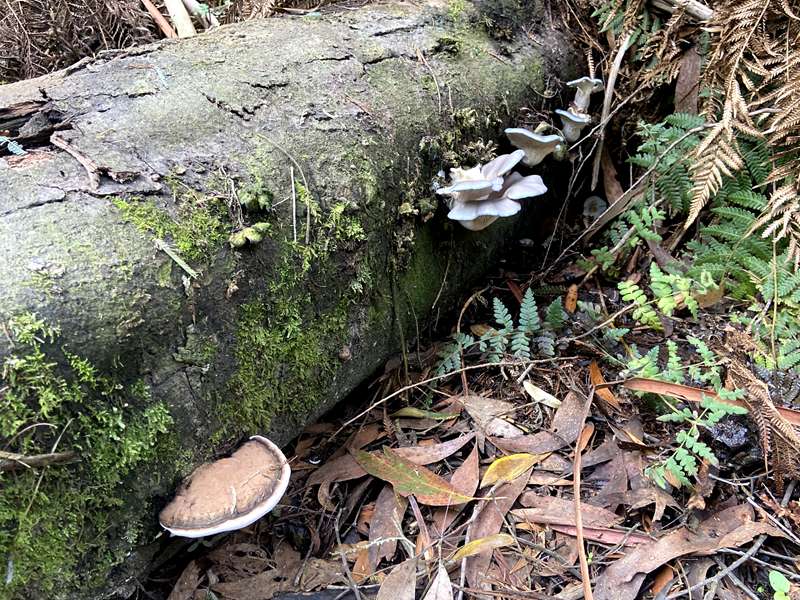
During the cooler months a fascinating display of fungi, from the large bracket fungi to tiny parasols, can be seen on the trunks of trees, tree-ferns, fallen logs and among the leaf litter.

5. Waterfall-Bower Track - 7km return, 2.5hr
This track combines part of the Moonlight Divide Track and features two small waterfalls at the midway point. More experienced walkers should tackle this track. Starting point is 301 Allambee Estate Road, Allambee.
Picnicking
The grassy flats and tree ferns at Moonlight Creek provide a delightful setting for a picnic. There is a shelter with two tables and a BBQ, seven unshaded tables, firepit and toilets. Camping is not permitted within the park.
History
Between 1860 and 1862, Surveyor George McDonald and his small team surveyed and cut a track through the thick forests of the Strzelecki Ranges from Lang Lang to Moe. Mount Worth is the highest point on the track.
During the 1870s selectors pegged out blocks on McDonalds Track, toiled to clear paddocks and build huts. During the 1920s, 12 timber mills operated on the slopes around Mount Worth to strip it of its valuable timber. Relics of the timber industry remain in the park including saw dust heaps, an old mill boiler and the formation of tramways used to haul timber to and from the mills.
The Warragul Field Naturalists Club and the Shire of Warragul were instrumental in having the park created to protect an example of the wet forests originally widespread in the Western Strzelecki Ranges. The park now encompasses 1,040 hectares.
Access for Dogs:
Cats and dogs are not permitted in the park. Camping and motorcycles are also prohibited.
Location and Access
Mount Worth State Park is situated approximately 125 kilometres south east of Melbourne. The park is reached from the Princes Highway at Warragul by following the Warragul - Korumburra Road, Grand Ridge Road and McDonalds Track.
Alternatively the park can be reached from Darnum via the Darnum - Allambee Road and the Allambee Estate Road. Roads are narrow and winding with gravel surfaces.
Friends of Mount Worth
Friends of Mount Worth meet on the first Sunday of every month at 10am in the Moonlight Creek Picnic Ground. Contact the Friends at: mtworthfriends@gmail.com or at https://mtworthfriends.wordpress.com.
"Excellent Country"
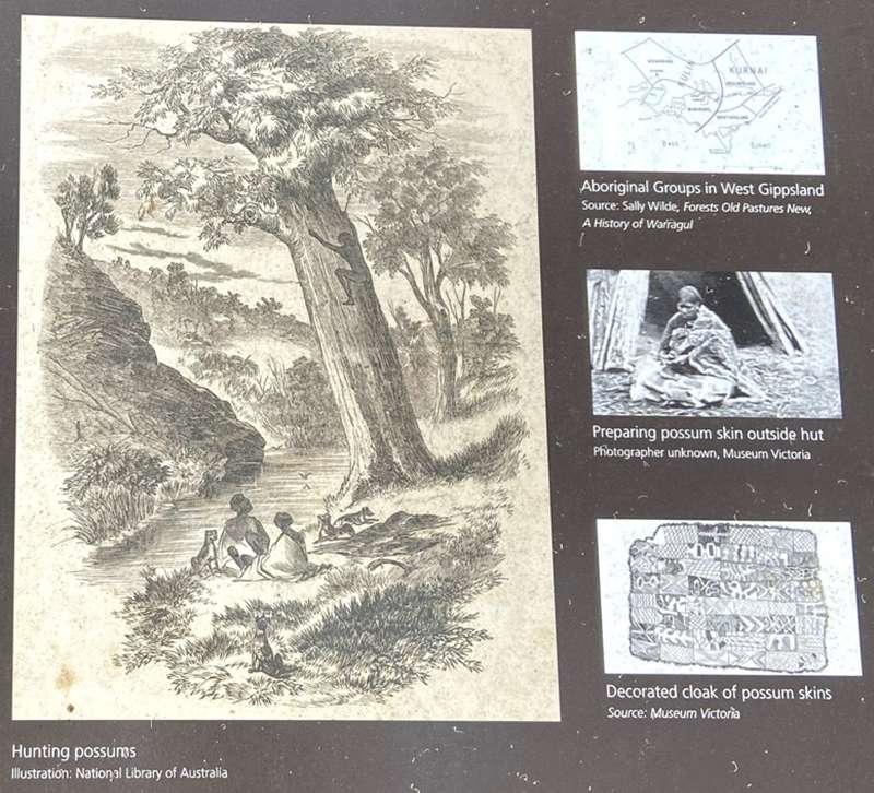
The area in which Mount Worth State Park sits was the land of the Bunurong (Boon Wurrung) people, part of the Kulin nation.
The general area was forest for thousands of hectares and was rich with food if you knew how to use it, as the Bunurong people did following thousands of years of tradition. The country was known in local language as "Marr-ne-beek" which is translated as "excellent country".
The Bunurong menu was heavily tilted towards vegetables with the Yam Daisy (Microserls scapigera) predominating, supplemented by many other varieties including fruits such as White Elderberry, Cherry Ballart, Lilly Pilly and Prickly Currant-bush. Young Austral Bracken (before the leaves open) made a regular boiled vegetable, while the roots could be roasted and beaten to form a (paste. Tree-fern tops provided a starchy staple either raw or cooked.
Tasty protein was relatively easily available in the form of possums, which only required some notches being cut in a tree to climb up and smoke it out of its nest. The hide then provided soft, warm and waterproof clothing and bedding; so was well worth the climb. Variety was provided by duck, kangaroo, wallaby, fish and birds (including the Lyrebird).
The environment also provided all that was needed for shelter with huts being constructed from bark cut from trees about 2 meters long with every alternate sheet reversed to make it quite water - and wind - proof. Possum skin and a small fire made the setup comfortable in most weathers.
The arrival of white settlers resulted in the dispossession of the Bunurong and this rich land being cleared of the environment supporting the natural bounty. The possum and other animals were hunted to the brink of extinction and the imported sheep so favoured the Yam Daisy that they would dig it up to eat till this primary Bunorong food was wiped out.
The small numbers of Bunurong remaining in the early 1900s were forced to move to Lake Tyers mission along with people from all over Victoria.
"Changing Times"
Standing on this spot (at the Picnic area) in 1947 you would have seen a sawmill operated by the Hurst family; Ted, Jean and their five children.
Their story was typical of other families in the area. Ted's parents moved here in 1920 as part of the Soldier Settlement Scheme following World War 1. Ted and Jean took over the family farm in 1945. Their family home "Ruthdale" was located up the hill behind the car park, where the camelia bush, planted in 1926, remains to this day.
By today's standards, life was difficult. There was no electricity or telephone. Cooking was done on a wood stove. Bread was baked daily and there were always home cooked biscuits. Butter was made by hand using butter pats. Rabbit was regularly on the menu, also chicken which they killed and dressed ready to eat. They grew their own vegetables.
Washing was done by hand using a scrubbing board and copper. Jean made all the children's clothes, knitted their jumpers and darned their socks. Cardboard was put in their shoes when holes appeared.
The children were expected to help milk the cows before going to school. They took it in turns to use the separator to produce cream to sell to the Yarragon Dairy. Before they had a sawmill, this was their only income. The skim milk was fed to the pigs.
School lunches were thick slices of home cooked bread spread with butter or plum jam; one or the other, not both. The sandwiches were wrapped in newspaper.
Farm work was done using horses until 1948, when they purchased a "Fergie" tractor, the first in the area. Neighbours came to admire it. They also bought their first family car.
Although life was tough, all the children consider these years were very happy and hold many special memories.
The family sold the farm in 1957 and moved to Drouin. Other families chose to move away. From 1979 to 1984, the State Government purchased land from farmers willing to sell in order to create Mount Worth State Park. Many of the trees and plants you see here today have re-grown since that time.
Historical Relics
At various points in the park, you will see relics of the timber mills that operated on the slopes around Mount Worth.
During the 1920s, twelve timber mills operated here. Steam-driven saws turned the huge logs into timber ready for despatch to towns along the main Gippsland Railway.
Getting the timber from these remote hill sites to the railway sidings at Darnum or Yarragon was a major problem. High rainfall turned steep bush tracks into muddy quagmires. The solution was to build tramways along which horses hauled wagons laden with timber. Sawdust was laid between the tracks to soften it for the horses hooves. Some of the walking tracks in the park follow the same route as the old tramways.
Trevorrow's Mill
All that remains of the sawmill that once operated here from 1923 to 1927 is a heap of sawdust and some old machinery. Further back on the track you will have passed the remains of the boiler that made the steam to drive the saws.
Imagine what it would have been like here when the mill was working. This would have been a large clearing with sheds, piles of timber and the noise of steam-driven saws. Twenty men were employed on the site. Although much of the forest has grown back, you can still see what is left of the sawdust heap where some plants are only now beginning to return.
Review:
We came to the park from Darnum and the road, which was initially asphalt and then gravel, was extremely twisty and narrow. We returned via Warragul and the road was much easier to traverse.
There are some tracks leaving from a point north of the Moonlight Creek Picnic area. They are the Moonlight Creek Track, Maslins Mill Track (900m one-way), Seymours Mill (2.3km) and Bromfields Mill (3km).
We did the Maslins Mill Track walk following the Moonlight Creek Track and came back on the Moonlight Divide track to the Moonlight Creek Picnic area. It's a wonderful walk through the tree-ferns beside the creek.
There are some tracks leaving from the carpark south of the Moonlight Creek Picnic area. The Giants Circuit (1.8km return), Standing Giant (600m), Trevorrows Mill (850m) and Gardiners No. 2 Mill (1.5km).
Previously we completed the Giant's Circuit but in April 2025 this track was closed due to trees over the track and damaged bridge. It is unlikely that this walk will be re-opened soon. This is a really interesting walk with the different types of trees labelled and a number of information signs.
However the other walks in this area are also lovely with lots of tree ferns.
The area has a wonderful range of colourful fungi of all shapes. We also saw two lyrebirds scratching in the earth beside the tracks.
The park is very well maintained with very good signage. That's handy because we didn't have any phone reception.
Photos:
Location
301 Allambee Estate Road, Allambee 3823 View Map
Web Links
→ Mount Worth State Park (Parks Victoria)
→ Mount Worth State Park - Visitor Guide (PDF)
→ Mount Worth State Park - Map (PDF)
→ mtworthfriends.wordpress.com
→ Friends of Mt Worth State Park on Facebook


")