Mount Baw Baw Walks (Baw Baw Village)


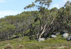
Mount Baw Baw offers the walker a choice of glorious walking trails around the village and surrounds. Take a leisurely stroll through the village, or take one or more scenic walks through the hills and through the snow gums.
The tours can be taken by yourself or as a guided walk.
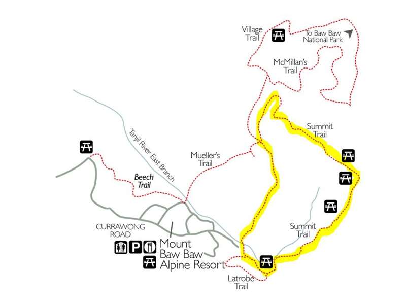
Mount Baw Baw Walks Map

La Trobe Trail
Length 750m/30 minutes
This trail provides a short walk with fine examples of Snow Gum woodland and provides stunning views of the Latrobe Valley along the way. The trailhead is located next to the Skiosk at the base of the skiing area. You will follow the trail along the edge of the popular Tank Hill Ski area before the trail turns and you find views over the Latrobe Valley, Westernport Bay and the Strzelecki Ranges. As you look out to the east you can see a dead grove of trees resulting from a lightning strike over summer.
As you venture left and follow the valley, you will skirt along the edge of an example of sub-alpine wet heathland. This area is made up of a variety of different shrubs, herbs and mosses, some that produce beautiful flowers throughout the summer months. This area is protected, as it is typical habitat of the Baw Baw Frog (Philoria frosti). Continue along this trail and you will return to the Skiosk and complete this walk. This trail is abundant with alpine flowers throughout the summer months; look for the unique Baw Baw Berry that can be found around the base of snow gum clumps.
Beech Trail
Length 2km/45 minutes
Commencing at the bottom of Candle Heath Drive the trail follows the East Tanjil River for a short section, before meandering through Snow Gum Woodland and small sections of subalpine wet heathland. This trail is tranquil with a variety of different flowers, shrubs and trees; in particular you will find small stands of the Myrtle Beech Nothofagus cunninghamii, after which this trail was named. This tree can be found along wet gullies and growing under snow gums on wetter slopes. This species can also be found in Tasmania.
Take a break and enjoy the setting amongst the snow gums from Saxton's Picnic Area. Look for the Grass Triggerplant with its beautiful pink flowers and Alpine Orites which is distinguishable by its creamy white flowers and is commonly found among rocks along the trail. When you arrive at the end of the trail, you can either backtrack the way you came or follow the resort access road back to the Village.
Village and McMillans Trail
Length 4.5km/approx 3 hours
The Village/McMillan's trails offer a relaxing walk through Snow Gum woodland and subalpine heathland. This trail takes you through the open areas of McMillan's and Baragwanath Flats; these areas showcase a wide variety of native orchids and wildflowers. McMillan's Flat is a prime example of subalpine wet heathland, which is potential Baw Baw Frog habitat. Baragwanath Flat is named after Mr Baragwanath, director of Geological Survey 1903, who was involved in the preparation of a geological map of the area.
The Baw Baw Frog is restricted to the Mt Baw Baw Plateau, where it lives in the wet heathland and sphagnum moss bogs. It may be found among the roots of heathland plants growing in the sphagnum or under fallen debris. The size of the frog population on the plateau appears to have declined in recent years. Along this trail you'll come across Anthill Lookout, affectionately named after a hungry colony of ants. This lookout provides views across the Tyers River catchment with Talbot Peak and Mt Erica in the background.
Summit Trail
Length: 2.5km/approx 2-3 hours
Start/Finish: Outside Mt Baw Baw Alpine Resort's ticketing and snow patrol office, at the base of the Summit T Bar lift.
The Summit trail takes you on a meandering climb to the summit of Mt Baw Baw (elevation 1564m) through Snow Gum woodland. Mt Baw Baw is the second highest peak on the Baw Baw Plateau. Situated at the summit is the historic cairn used as a survey reference in 1903. Along the trail you'll find several picnic areas and many varieties of native flora and fauna. Three picnic areas including Mueller's Lookout, Summit Cairn and Downey's are perfect for resting and enjoying views over lunch or a quick snack.
Mueller's Lookout and picnic area, named after the first European to climb Mt Baw Baw, Baron Ferdinand von Mueller, provides magnificent views of Mt St Phillack, St Phillack saddle and Mt St Gwinear. In the distance to the northeast is the Snowy Range & Bennison High Plains. To the North are Mt Buller and Mt Stirling. Further along the trail is the Summit Cairn picnic area which provides stunning views of the Strzelecki Ranges and the LaTrobe Valley. This is a heritage-listed site, please respect it for future generations and refrain from climbing the cairn.
Heading down valley you'll find Downey's picnic area secluded amongst snow gums and home to the Sooty Owl. As you relax on the tables you'll notice a unique blend of new and burnt out snow gums. These burnt snow gums are a product of the 1939 fires also known as 'The Black Friday Bushfires' and are now home to the Sooty Owl and various other birds. The Sooty Owl is extremely rare and has been spotted at dusk. Along the trail near the summit, look for the Cascade Everlasting and, near the intersection of Summit and LaTrobe trails, the Wax-berry. This shrub is rare to the area and produces a waxy, white-pink berry that forms in mid to late summer.
Access for Dogs:
Dogs are not permitted.
Location
Mount Baw Baw Tourist Road, Baw Baw Village 3833 View Map
✆ (03) 5165 1136
Email Enquiry
Web Links
→ www.mountbawbaw.com.au
→ Mt Baw Baw Alpine Resort on Facebook


