Mildura Riverfront Shared Path

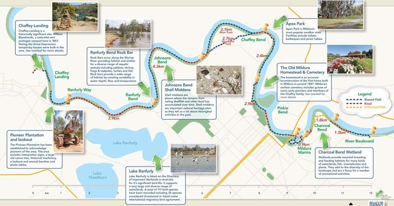
The Mildura riverfront shared path is designed for pedestrians and cyclists to enjoy scenic views of the spectacular Murray River and local natural environment.
The path includes both areas of relatively high recreation use, such as Apex Park within Chaffey Bend and the Mildura Marina to Lock 11, to more secluded areas, such as the River Boulevard near Benetook Avenue and Chaffey Landing, Merbein.
Vegetation communities include Riverine Grassy Forest, dominated by River Red Gum trees, and Black Box Chenopod Woodland.
Along the path you will find scenic picnic spots, interpretive signage and areas of cultural and historical significance.
Although most of the path along the riverfront is exclusively for pedestrians and cyclists, the path includes some areas of roadway. There are also some small sections of unmade path where the path has not yet been constructed. Please refer to the map for details about the type of path provided. The path can be accessed from a number of areas along the river, with various access points at most locations including the River Boulevard, Chaffey Bend, Johnsons Bend, Ranfurly Bend and Ranfurly Way.
The Murray River in Victoria is unique in the world, being one of the few major rivers where the public can freely and openly access the bank along its entire length. Along the length of the Murray River in Victoria, a strip of land approximately 60 metres (or 3 chains) in width was permanently reserved for public purposes in 1881.

Download Mildura Riverfront Shared Path Map
Key Locations
Chaffey Landing
Chaffey Landing is a historically significant site. William Blandowski, a naturalist and zoologist camped here in 1857. During the Great Depression temporary houses were built in the area.
William Blandowski, naturalist and zoologist, had been commissioned by the National Museum of Victoria to proceed to the junction of the Darling and the Murray Rivers to 'investigate the local natural history and collect specimens for the National Museum.' In early April, 1857, Blandowski's expedition chose to camp 'in a finely sheltered position below some sandstone cliffs' (Chaffey Landing) called 'Mondellemin' by the Aboriginal people. This became his base for collecting specimens until 6th August, 1857, when he set out for Adelaide.
'Bag Town' - During the Great Depression of the 1930's, when unemployment reached over 29%, temporary homes, mostly made of hessian type material, were erected along the Murray River bank in the Merbein area. This collection of temporary homes, housing many families and itinerant workers, became known, locally, as Bag Town and stretched intermittently from Old Mildura (end of the 'Mad Mile') to the Abbotsford Bridge.
A 'Bag Town' settlement of mostly wood cutters also existed at Merbein West. Over eight temporary 'houses' of varying size and construction were located in the vicinity of Chaffey Landing.
Pioneer Plantation and Lookout
The Pioneer Plantation has been established to acknowledge pioneers of the area. The area includes interpretive signs, a large old canoe tree, historical machinery, a lookout and several benches and picnic tables.
Ranfurly Bend Rock Bar
Rock Bars occur along the Murray River providing habitat and shelter for a diverse range of aquatic animals including yabbies, shrimp, frogs and tadpoles, turtles and fish. Rock bars provide a wide range of habitat by creating variability in water depth, flow and temperature.
Lake Ranfurly
Lake Ranfurly is listed on the Directory of Important Wetlands in Australia for it's significant bird life. It supports a very large and diverse range of waterbirds. A total of 117 bird species have been recorded including 26 species considered threatened or listed under international migratory bird agreement.
Uchter John Mark Knox was born (presumably in Ireland) on the 14th August 1856. At the age of 19 he became the 5th Earl of Ranfurly, after his brother died while on a shooting expedition in Abyssinia on 10th May 1875. He came up to Mildura on the 23rd June 1888 and purchased 160 acres of freehold land adjoining what is now Lake Ranfurly; the area was then known as Old Mildura.
The property was cleared and developed with mainly apricots, citrus and vines.
The Lord Ranfurly enjoyed horse racing and was the first President of the Mildura Club in 1890. He was credited with being the first person to grow Washington navels in Australia and was the first exporter of oranges to London.
His Lordship died 1st October 1933. An obituary appeared in The Times (London) on 2nd October 1933. In the obituary it mentions "...and he spent some time in Australia fruit growing".
Johnsons Bend Shell Middens
Shell middens are places where the remains from eating shellfish and other food has accumulated over time. Shell middens are important cultural heritage sites as they tell us a lot about Aboriginal activities in the past.
Apex Park
Apex Park is Mildura's most popular sandbar area. Facilities include toilets, barbeques and picnic tables.
The Old Mildura Homestead and Cemetery
The homestead is an accurate reconstruction of the first home built in Mildura in around 1847. It is built on the site of the original "Mildura" pastoral lease and station established by the Jamieson brothers in 1847. It was here that the Chaffey vision for the irrigation colony evolved. The re-creation consists of the homestead, outbuildings, the wool-shed and rose garden. The Homestead is open seven days from 10am-4pm. Mildura's earliest cemetery includes graves of some early pioneers of the Chaffey family. Antonia Chaffey, great grand daughter of W.B. Chaffey, has designed a commemorative garden beside the burial site of the mother of the Chaffey brothers, Ann Maria and W.B.'s first wife, Hattie Schell, as well as four infants. The gardens comprises a granite sculpture and observation seat.
Charcoal Bend Wetland
Wetlands provide essential breeding and feeding habitats for many kinds of waterbirds, fish, invertebrates and plants. They add to the diversity of the landscape and are a focus for a number of recreational activities.
Location
Chaffey Landing Track, Mildura 3500 View Map


