Maryborough - Paddys Ranges Cycling Trail

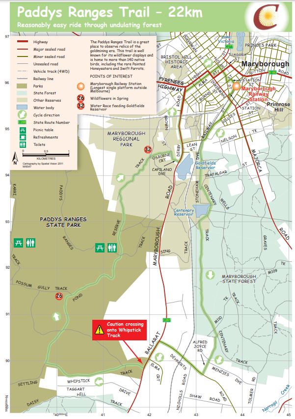
A reasonably easy 22km ride through undulating forest. The Paddys Ranges Trail is a great place to observe relics of the goldmining era. This trail is well known for its wildflower displays and is home to more than 140 native birds, including the rare Painted Honeyeaters and Swift Parrots.
Paddys Ranges Cycling Trail Map

Download Paddys Ranges Cycling Trail Map
Major Trail Features:
26. Wildflowers in Spring
32. Water Race feeding Goldfields Reservoir
Notes:
- Tracks are signposted in the direction of travel indicated on map. If there are no track markers present continue travelling straight.
- Tracks are usually suitable for mountain and hybrid bikes. Off road tracks follow forest roads with mostly gentle grades and very little vehicular traffic. Surface conditions will vary depending on weather and maintenance
- No fires may be lit on days of Total Fire Ban. This includes gas or fuel stoves in tents. All other fires must comply with relevant regulations
- Drinking water may not be available outside of townships
- Public toilets are located at Dunolly, Avoca, Carisbrook, Talbot, Timor, Paddys Ranges Picnic Ground and Majorca
- Varied mobile telephone reception is available in all areas
- All cycling tracks begin at the Maryborough Railway Station, Station Street, Maryborough.
- Listed distances are estimated only.
Location
Station Street, Maryborough 3465 Map
Web Links
→ Paddys Ranges Cycling Trail Map (PDF)
→ Cycle Central Goldfields Guide
→ Cycle Central Goldfields Brochure (PDF)


