Maryborough - Majorca Kong Meng Cycling Trail

A reasonably gentle 23km ride through forest and township. Majorca was founded in 1863 towards the end of the Victorian gold rush after two prospectors struck gold at nearby McCallum's Creek. Two months later, there were 250 stores and restaurants catering to a population of around three to four thousand, although many shops and residents soon returned to nearby Maryborough. The town size was sustained for over 50 years through gold mining, including the Kong Meng Mine.
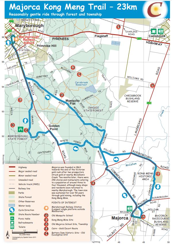
Majorca Kong Meng Cycling Trail Map

Download Majorca Kong Meng Cycling Trail Map
Major Trail Features:
20. Old Mosquito School
21. Kong Meng Mine Site
22. Old Majorca School Site, Township
23. Cairn - Gold Escort Route
24. Battery Dam Historic Site - Old Eucalyptus Still
Notes:
- Tracks are signposted in the direction of travel indicated on map. If there are no track markers present continue travelling straight.
- Tracks are usually suitable for mountain and hybrid bikes. Off road tracks follow forest roads with mostly gentle grades and very little vehicular traffic. Surface conditions will vary depending on weather and maintenance
- No fires may be lit on days of Total Fire Ban. This includes gas or fuel stoves in tents. All other fires must comply with relevant regulations
- Drinking water may not be available outside of townships
- Public toilets are located at Dunolly, Avoca, Carisbrook, Talbot, Timor, Paddys Ranges Picnic Ground and Majorca
- Varied mobile telephone reception is available in all areas
- All cycling tracks begin at the Maryborough Railway Station, Station Street, Maryborough.
- Listed distances are estimated only.
Location
Station Street, Maryborough 3465 Map
Web Links
→ Majorca Kong Meng Cycling Trail Map (PDF)
→ Cycle Central Goldfields Guide
→ Cycle Central Goldfields Brochure (PDF)


