Maribyrnong River Walking Trail (Avondale Heights)

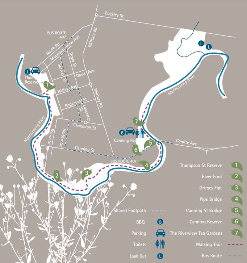
Enjoy the sights of this beautiful section of the Maribyrnong River during this 5km (one-way) walk. Once known as the 'Saltwater', the Maribyrnong River has played an important part in the history of the area. This walk begins at Thompson Street Reserve and ends at the historic Riverview Tea Gardens, incorporating many sights of interest along this magnificent waterway.
Difficulty: Moderate
Surface: Gravel
Limited wheelchair access: Access to the trail can be gained at Canning Reserve. The track is gravel and may prove difficult for people in wheelchairs.
Bus information: For bus information on the return journey see map or 'getting home again' section.
Maribyrnong River Walking Trail Map

Maribyrnong River Walking Trail Notes
1 Thompson Street Reserve
Accessed via North Road, this reserve provides exciting views of the Maribyrnong Valley. Walk down the hill to the river path.
1.5 Kilometres to River Ford.
2 River Ford
In the years before the construction of bridges and the establishment of punts, the river had to be crossed via fords. The fords gave settlers their first access to the areas west of Melbourne. This reconstructed ford can still be crossed safely by careful pedestrians, except when affected by flooding or heavy rainfall. Try a river crossing if you are feeling brave. Just tread carefully!
One Kilometre to Grimes Flat.
3 Grimes Flat
'Grimes Flat' was named after Charles Grimes, the surveyor to the Cumberland expedition. The first white man to see this section of the Maribyrnong, Grimes described it as beautiful beyond description: This part of the walk incorporates native flora, mainly River Red Gums and Silver Wattles. Cormorants, ducks and other water birds are frequent visitors to this section of the river.
One Kilometre to Pipe Bridge.
4 Pipe Bridge
This bridge holds a water main that supplies water to Melbourne's western suburbs. If you wish, you can cross the bridge via the walkway. It provides a wonderful view of the river.
One Kilometre to Canning Street Reserve.
5 Canning Street Bridge
The current bridge was built to replace a narrow military bridge built in 1921. Walkers should be able to see the abutment of the original bridge on the far riverbank.
6 Canning Reserve
Canning Reserve was purchased from the Crown by John Aitken in 1846. The northern edge of Canning Reserve was part of the Riverview Tea Gardens. The reserve has BBQ facilities, fishing platforms, a playground and is a lovely place for a picnic. Watch the river closely for bird life as you walk along.
0.5 Kilometre to the Tea Gardens.
7 The Riverview Tea Gardens
The Riverview Tea Gardens were established in 1909 by the Hicks family to take advantage of the then popular river excursions from the Maribyrnong Road Bridge. Facilities included tennis courts, pavilions and a dance hall. As such, the Hicks family soon had a monopoly on the Maribyrnong pleasure cruises. During World War II, a boom was placed across the river as a security measure. Asa result, the cruises declined in popularity, and the Tea Gardens ceased operation in 1947.
Today, little remains of this historic site apart from the rockwork near the bank of the river, however the reserve still provides a great area for picnics. The white lady statue was part of the original garden layout It went missing in the 1980s, and this replacement was erected in the 2000s.
Getting home again
Of course, the most picturesque way to return to the starting point is to walk back up the river. However, should you be a little leg weary, an easy way to return to Thompson Street Reserve is to walk back to Canning Reserve and up to Canning Street. From there, you can catch the Number 407 bus to North Road to your point of origin.
Other points of interest
Fishing Platforms are located in Cranwell Street Reserve and Canning Reserve, on Afton Street Footbridge, in Newsom Street and Fisher Parade. The main types of fish to be caught are Bream and Mullet.
Location
139 North Road, Avondale Heights 3034 View Map
Web Links
→ Maribyrnong River Walking Trail Brochure (PDF)


