Korumburra Heritage Plaques

Wander down Korumburra's main street (Commercial Street) and notice plaques which have been carefully researched and installed by the Korumburra Historical Society.
The plaques are on the southern side of Commercial Street plus the area near the Austral Hotel.
Plaques include:
The Cenotaph
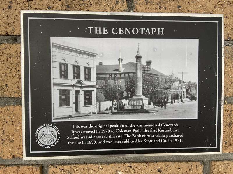
Location: 36 Bridge St, Korumburra
This was the original position of the war memorial Cenotaph. It was moved in 1970 to Coleman Park. The first Korumburra School was adjacent to this site. The Bank of Australasia purchased the site in 1899, and was later sold to Alex Scott and Co. in 1971.
The Austral Hotel
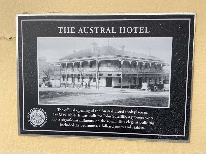
Location: 34 Bridge St, Korumburra
The official opening of the Austral Hotel took place on 1st May 1894. It was built for John Sutcliffe, a pioneer who had a significant influence on the town. This elegant building included 22 bedrooms, a billiard room and stables.
Sutcliffe Building
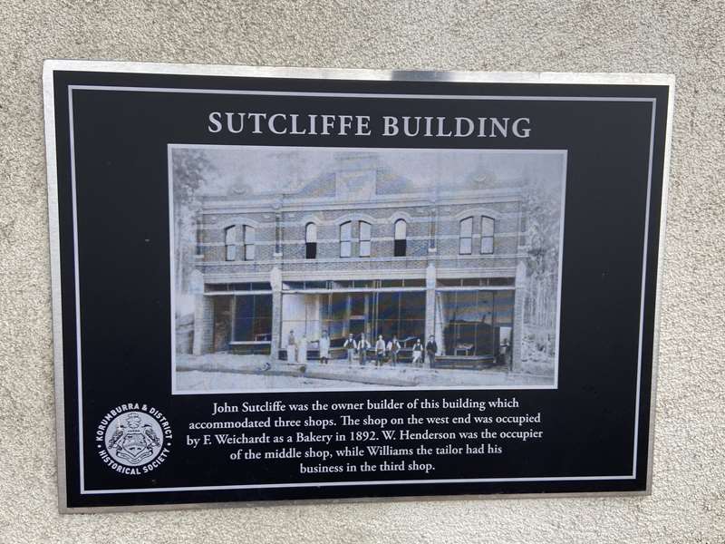
25 Commercial St, Korumburra
John Sutcliffe was the owner builder of this building which accommodated three shops. The shop on the west end was occupied by F. Weichardt as a Bakery in 1892. W. Henderson was the occupier of the middle shop, while Williams the tailor had his business in the third shop.
Wrench Bootmakers
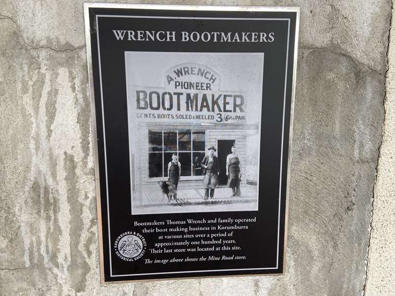
Bootmakers Thomas Wrench and family operated their boot making business in Korumburra at various sites over a period of approximately one hundred years. Their last store was located at this site.
Korumburra Hotel

By the end of 1888 Antonio Radovick had completed his Korumburra Hotel which became the venue for many of the town's activities. The official opening was cause for great celebration which took place in June 1891, the same year as the arrival of the railway line.
Burnet's Hardware

There has been a hardware store on this site since 1893. It was operated by the Burnet family until 1963. Next to it was the National Bank of Australasia and on the other side, Dwyer Bros. tobacconists and Cope Bros. Tailors, also established in 1893.
The Foreman Buildings

The three shops in the foreground were built on this site in 1892. The first businesses operating here, were a newspaper office, a jeweller and musician, "The Colliery Store" and a mixed business and barber's shop.
Korumburra History
Those Early Years
The green fields of the Korumburra district were once The Great Forest of South Gippsland; tall blue gum and messmate trees with a dense under-story that blotted out the sun, so that early selectors were said to have become lost on their own 320 acre selections.
Although the rich soil is some of the most productive in Victoria and Australia, district settlement was late in colonial development. It was not until the passing of the second Grant Land Act in 1869 that it became practical to select in the high-rainfall hill district. In addition, access to the area was difficult, through the dense bush and Koo Wee Rup swamp, and each selector needed capital to clear the land and bring it to productivity. Many tried and failed, but others survived the hardship and poverty of those settlement years to become land owners of high quality land, a situation that would not have been possible for ordinary people in the European lands from which most of them had come. It is significant that many of the early settlers came to South Gippsland from the declining goldfield areas, possibly with some capital to invest in their land development.
Although railway construction was expensive in this terrain, a line was constructed from Dandenong to Port Albert in 1891. This provided a connection to markets for the selectors, but also provided access to the black coal deposits at and around Korumburra. Mines were established and a service town developed around the railway station and the Korumburra Hotel that had been established by the dynamic Croatian/Irish couple Antonio & Elizabeth Radovick. Spur lines were built to major mines, and a branch line constructed to the mines that became established at Outtrim and Jumbunna. Coal was then as important to the national economy as oil was later to become.
As selectors established viable farms, small butter and cheese factories were established about the district. The Korumburra Butter Factory was massively expanded in 1909 to become the biggest butter factory in the southern hemisphere. The high-volume production of this co-operative gave direct access to the important London market, bypassing the exporters and dealers whose activities had inhibited farming prosperity.
During the last decades of the twentieth century the Korumburra saleyards became the benchmark bullock sale for south-eastern Australia, a further indicator of the outstanding productivity of land that once had been the Great Forest.
Later Times
The farming district has continued to prosper, and Korumburra is a service town for the farming community. The cattle saleyards have been demolished, as technology has Changed the nature of livestock marketing. The last commercial coal mine [the Sunbeam] closed in 1958, but the industry had declined from the opening of the Wonthaggi State Mine before the First World War. The Wonthaggi seams were thicker and less faulted than those in the Korumburra district. Outtrim and Jumbunna, once significant towns, disappeared with the closing of the Mines and the branch railway, deprived of coal traffic, was dismantled. They remain as districts with strong community ethos and now they are experiencing a mild renaissance with new owners building on the old township blocks.
The grand Korumburra Butter Factory closed in the 1970s with rationalisation of the industry, but has re-opened, as Burra Foods. Once again processing locally produced milk, with a wider range of dairy products. As this is being written, further development of production lines is proceeding, made possible by the availability of natural gas for economical steam raising.
The main railway line is closed, except for a tourist operation between Nyora and Leongatha. Contact with Melbourne is now by a highway that is becoming increasingly busy, and motorists in air-conditioned cars do not notice the old barriers of the Koo Wee Rup Swamp or the Tinpot Hills.
Korumburra is a fascinating town and district, with a colourful past and a confident future: a future that is based, as Antonio & Elizabeth Radovick predicted, on the soil and not on the coal that is under it. The miners have moved on, and remembered only by a few brass plaques that record the lives lost in just those few years of activity.
KORUMBURRA - a dot-point history
Pre-Colonial: The site of Korumburra and district was the Great Forest of South Gippsland. The hills were covered with a dense forest of blue gums and messmate with a dense under story. The indigenous people were the Bunurong people; hunters and gatherers, they mostly inhabited the sandy, coastal areas where there was a variety of wildlife. The rugged, densely forested highlands seemed to have little permanent occupation. Evidence of their presence has been found at sites along the Bass River.
1842: Count Strzelecki led an exploration party through the area.
1860s: Surveyors such as McDonald, Whitelaw and Larkin cut survey lines through the forest which served as dray tracks to provide access. grazing leases were registered but they appear to have been mostly speculative.
1874 First selections: It was not until after the passing and implementation of the Second Grant Land Act 1869 that it was practical to settle in the steep inaccessible forest. One feature of the Act was that it allowed selection prior to survey. The soil was extremely rich and the climate wet, but the district was un-attractive to those without capital. It required capital to clear the forest and to bring a farm to productivity and there would be a considerable delay before a return could be expected. Access was extremely difficult without a local road system in the steep and muddy hills. Also, the absence of a railway or trunk road and the considerable barrier of the Koo Wee Rup swamp inhibited selection. Many of the selectors were from the worked out goldfields of Victoria, and it is to be assumed that most of them would have had at least some personal capital.
The first selector, in 1874, was James Scott on land adjoining 'McDonald's Track' west of Poowong. [Miss Fanny Mauby selected a block at the same time, a block that she soon abandoned. She took up another selection later, and when she married Mr. Wallace Dunlop, an adjacent selector, their blocks were worked together.] Other selectors followed, initially along the survey track and later along the waterways. A rough dray track was established from the main Gippsland railway at Drouin, and a township of Poowong sprung up at the junction of this track with that of McDonald. In a few years all of the best land in that hill country was selected.
1887 Township of Korumburra: The township was officially gazetted and the first blocks auctioned. Antonio & Elizabeth Radovick purchased the most sought after blocks in Commercial Street and built the Korumburra Hotel which was to be the centre of commercial and social development in the early years. Mines were established and commenced to stock pile coal in anticipation of the construction of the South Gippsland railway.
1891 The Railway: The Dandenong to Port Albert railway line was completed and opened, and coal mining boomed with coal from the district being transported to Melbourne.
The Shire of Poowong &Jeetho was created, with the shire office established at Jeetho. [The original building is in good condition and is used by the Jeetho community as a local hall].
1939-45 Second World War: During the first part of the war years, Korumburra was officially declared a 'Vulnerable Area' An evacuation plan was prepared, air raid shelters constructed, first aid post established, and plane spotting towers manned near the top of Commercial Street and at Mt. Misery near Outtrim.
1945-50s Again - Soldier Settlers: The new Soldier Settler Scheme was well financed, well organised and well supported, and the blocks were of adequate size. Most of the returned men settled on the properties were from local families and familiar with the requirements of South Gippsland farming. There were estates at Kongwak, Moyarra and Nyora. There was a considerable inflow of Italian migrants, whose hard work developed much of the steeper hill country.
Shortage of building material and tradesmen caused the new settlers, migrant and Australian born, to live in sub-standard conditions in sheds and caravans for a few years, but they were no different to the young families in the town, where the demand for housing far outstripped the supply. The Housing Commission of Victoria developed land and erected houses in several parts of the town, and similarly the Victorian Railways imported pre-cut homes for their employees. These homes have mostly passed to private ownership.
1958 Closure of the 'Sunbeam': The last commercial coal mine, the 'Sunbeam: closed. Some small 'shows'worked after that time, providing for a small domestic market. Some of the unemployed miners were employed on the sewerage works then in progress, particularly on the hard-rock tunnel under the main ridge of the town.
1973 Closure of the Butter Factory: The Korumburra Butter Factory co-operative had amalgamated with others to form the South Gippsland Milk Industries co-operative. This in turn was absorbed by the larger Murray Goulburn co-operative. The Korumburra factory, with its obsolete machinery that had been state-of-the-art in 1909, was closed.
With the loss of the main employer of labour in the town [some 280 employees at closure, and up to 400 in more labour intensive times], the shire council purchased 173 acres of land on the western fringe of the town for an industrial estate and for saleyard expansion.
1974 Coal Creek: In February 1974, Coal Creek Historical Park was opened by the then-premier of Victoria, Richard Hamer.
1974 Saleyards: The first stage of expansion of the local cattle selling centre was commenced. This saleyard was to become the regional yard for South Gippsland with one of the highest through-puts of fat cattle in the state, and the benchmark bullock market for south-eastern Australia.
1976 Rural Recession: As with other rural areas of Australia, the Korumburra district was badly shaken by the collapse of markets for rural produce. With the rich local soil, the area was quick to recover, but the recession set in train a change of rural land use. Some smaller units moved to more intense use of land, but other more traditional operations turned to acquisitions of adjacent land to use modern technology to manage larger herds and enterprises.
1993 Closure - Great Southern Railway: After several withdrawals of services, resumptions a lengthy public enquiry, the Great Southern Railway was closed. A tourist railway now operates over part of the line.
1994 Dissolution of the Shire of Korumburra: The Shire of Korumburra as a municipal entity was dissolved in November 1994, and the Korumburra area was incorporated into the Shire of South Gippsland.
2000s: Korumburra now stands as a service town to a town of about 5000 population. Burra Foods has established at the old butter factory site, processing local milk to a wide variety of products. The once exciting regional saleyards is demolished, as changed meat and livestock industry needs made the operation un-viable. The financial crisis has closed some businesses in the town, but the community retains a strong sense of support and loyalty, perhaps typical of a community with a settler and miner past.
New housing estates and new homes proliferate, including at the old townships such as Jumbunna, as new people come for the scenery, the community, and the lifestyle. So it may continue.
Photos:
Location
Commercial Street, Korumburra 3950 View Map


")