Goldfields Track (Mt Buninyong - Bendigo)


The Goldfields Track is a point-to-point 210km track that takes mountain bikers and bushwalkers through some of central Victoria's most historic towns and beautiful forests. including through the heart of Victoria's historic Goldfields.
Originally known as the Great Dividing Trail, this is some of the most beautiful mountain biking and hiking in Victoria. A region steeped in history, you'll encounter forests, both natural and man-made, pastoral countryside and single track that in some places flow on grippy loam and in other jump and jag across roots, rock ledges and coarse sandstone. It is an unforgettable experience.
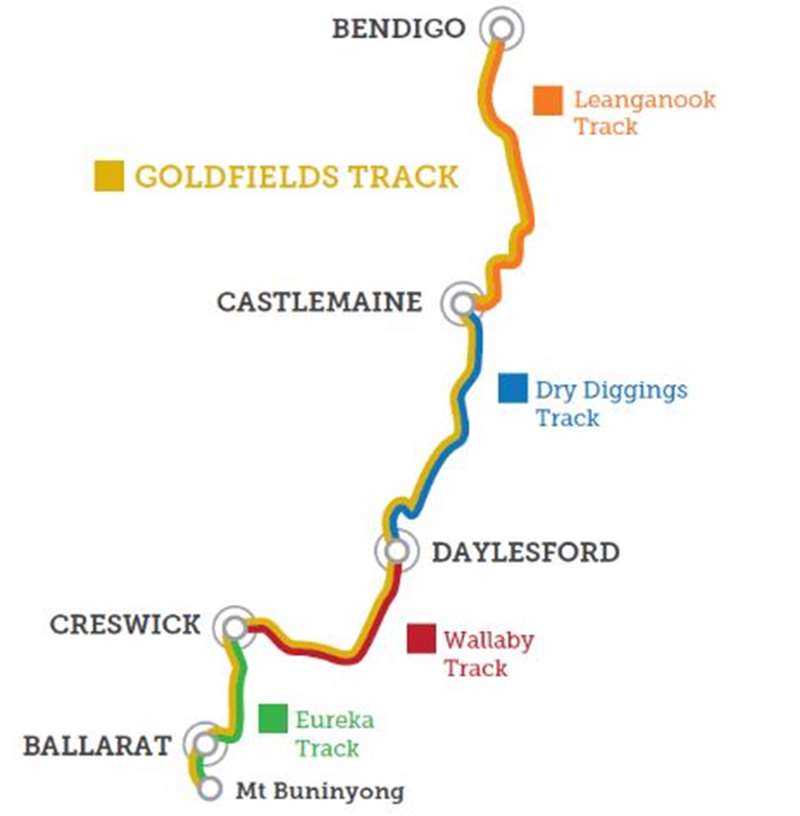
The 210km Goldfields Track comprises four smaller tracks, each having its own charm and features.
Map of Sections of Goldfields Track

Eureka Track
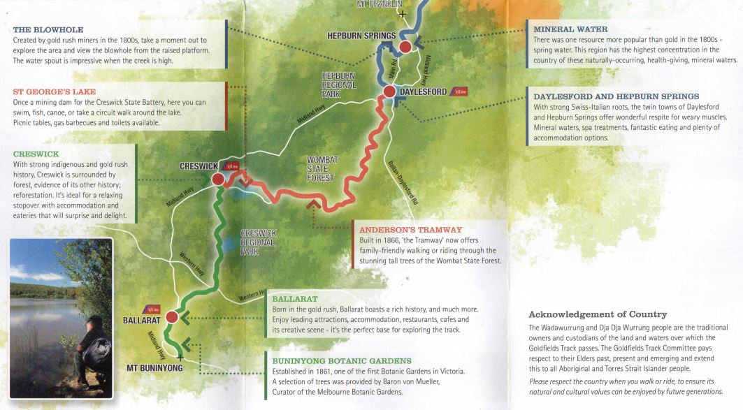
Mt Buninyong to Creswick - Approx. 43kmNamed after the famous miners' uprising in 1854, the Eureka Track starts with Mt Buninyong's panoramic views and ends in artist Norman Lindsay's home town of Creswick. You will encounter a mix of intact gold rush streetscapes, regrowth native forest and landscapes dotted with goldrush history.
Wallaby Track
Creswick to Daylesford - Approx. 52kmDeparting Creswick it's around St Georges Lake and past rolling pastoral countryside ringed by rich volcanic hills. You'll follow the state's longest timber railway system including an impressive one kilometre railway cutting. As you head into the Wombat State Forest it grows ever taller as you travel over the Great Divide. The beautiful forest delivers climbs and descents and you'll be ready for all that is on offer when you reach Lake Daylesford.
Dry Diggings Track
Daylesford to Castlemaine - Approx. 58kmThis section of track is the most popular with bushwalkers and mountain bikers alike. A roller coaster journey, with great single track, ever changing bush, plenty of goldrush artefacts, many car access points and a giant slide at Vaughan Springs! This section is challenging, fun, interesting and super accessible.
Leanganook Track
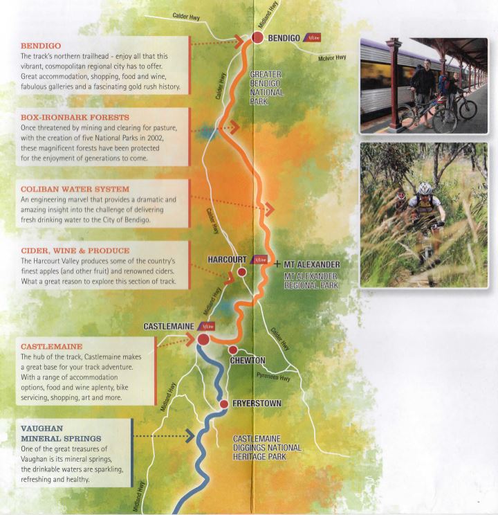
Castlemaine to Bendigo - Approx. 61kmYou'll need your climbing legs for the first section, but once you are past Mt Alexander the track flattens out for the run into Bendigo. Much of this section follows the spectacular Coliban Water System, and takes in Box lronbark forests and closer to Bendigo, flora reserves that are a must in spring.
The Goldfields Track provides a European style travelling experience. Regional cities and picturesque villages are always nearby, with a host of accommodation options, cafes, restaurants, wineries, shopping, day spas and galleries - all the ingredients for a memorable break from your everyday routine.
Map of Northern Section of Goldfields Track

Map of Southern Section of Goldfields Track

Elevation Map of Goldfields Track

Getting on Track
By Road
If travelling from Melbourne the key towns are easily accessed:- Ballarat: 75 mins via the Western Hwy
- Daylesford: 90 mins via the Calder and Daylesford/Trentham Road, or via the Western Hwy and Ballan/Daylesford Rd
- Castlemaine: 80 mins via the Calder Hwy
- Bendigo: 90 mins via the Calder Hwy, or the Hume and McIvor Hwys.
By Train or Bus
The Goldfields Track is well-serviced by public transport, with regular V/Line train services to Ballarat, Castlemaine and Bendigo. So leave the car at home and arrive relaxed and ready to hit the track. Harcourt, Creswick and Daylesford are serviced by the V/Line bus network. There is also a daily train service to Creswick.Bikes can be carried free of charge on V/Line trains, provided there is space available. It's recommended that you travel during off-peak times, as fares are cheaper and there is generally more room available. Note: bikes are not permitted on buses and only on trains if space is available.
For more information visit www.vline.com.au or call 136 196.
Staying safe
The Goldfields Track is a natural bush track that can sometimes feel quite remote, although it passes through several towns and villages. The track is clearly signed with gold-topped marker posts and directional signage. However you should always carry a map.
Getting ready to tackle the track?
- Tell someone where you are going and when you expect to arrive.
- Carry sufficient food and water. The track has no potable drinking water.
- Take out whatever you take in. Don't leave rubbish.
- Be prepared for changeable weather. Take suitable clothing, sunscreen etc.
- Don't rely on your mobile phone. Coverage is limited.
- Don't walk or ride on Total Fire Ban days or in any extreme weather. Check weather and track conditions at websites such as Vic Emergency. Bushfire Information Line: 1800 240 667.
- Keep to the track to avoid unseen mine shafts and to prevent damage to plants and cultural relics.
- Some sections of the track cross or use vehicle tracks. Take extra care on these sections.
- Camping is permitted in national and regional parks. Campsites are marked on the available maps.
- Be aware of and adhere to any current health restrictions and requirements for regional Victoria.
Location
Wallaby Track, Buninyong 3557 View Map
Web Links
→ goldfieldstrack.com.au


