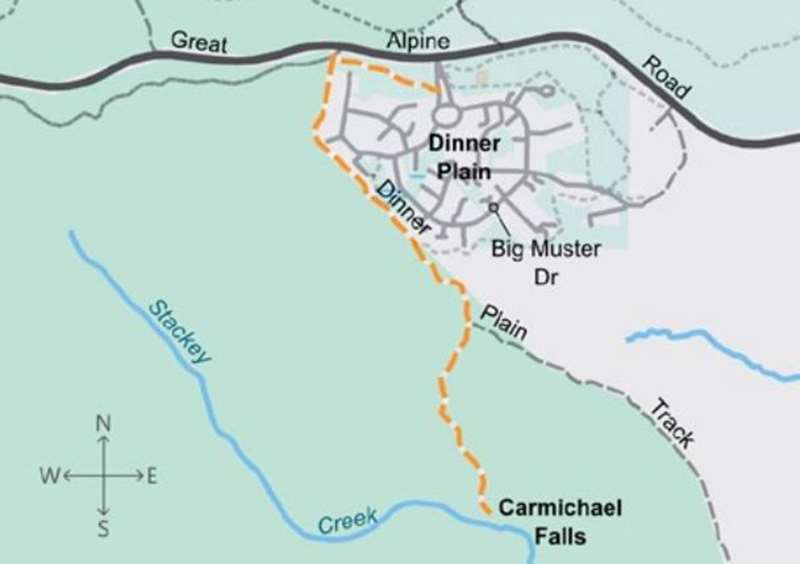
Dinner Plain - Carmichael Falls Walk


Heading off along the Dinner Plain 4WD track, this single track trail within the Alpine National Park descends through snowgum forest to a viewing platform overlooking the picturesque Carmichael Falls. It's a short 1km down to the lookout but the hike out will get your heart pumping.
Dropping 25 metres over basalt cliffs, the falls are in the headwaters of Precipice Creek and the Dargo River, which are among the many waterways feeding the major catchments arising at the Dinner Plain plateau. The actual falls are in fact two falls side by side at the confluence of the Precipice and Dinner Plain Creeks which rise in the alpine bogs of the Dinner Plain Village.
The trail ends at the viewing platform, but adventurous hikers may be tempted to scramble down to the base of the waterfall along an unmarked route. This terrain is on uneven ground with many unstable objects and long grass along the way and should only be attempted by experienced and confident hikers with an ability to navigate in unmarked territory. Please also be careful near the base of the waterfall, which may be slippery.
An alternative longer walk is:
Distance / time: 4 km / 1 hr
Grade 3: Some experience recommended. Formed track with hills and some obstacles. Signposted.
Start at Dinner Plain Hut and cross Horseshoe Circle to join the Brabralung Trail for 350 m until you reach Dinner Plain Track. Turn left. Follow the track for 1 km then take the trail on your right down to a platform overlooking a small waterfall. Return the same way.
Warning: This walk falls above the snowline.
Carmichael Falls Walk Map

Location
Dinner Plain Track, Dinner Plain 3898 Map
Web Links
→ Carmichael Falls Walk (Visit Dinner Plain website)
→ Dinner Plain Alpine Village on Facebook
→ Carmichael Falls Walk Track Notes with Map


