Dimboola - Little Desert National Park


The 132,647 hectare Little Desert National Park extends from the Wimmera River in the east to near Naracoorte in the west. Little Desert is much more than a desert. Camp beside the tranquil Wimmera River fringed with River Red Gums, or hike the rolling dunes of the desert. Wide open spaces and peaceful campgrounds make this park a natural treasure, best seen on foot in autumn, winter and spring. The river end is ideal to visit in summer.
The best time to visit the park is between late winter and early summer when the temperatures are comfortable and the park is full of blossoms and wildflowers. Camp beside the Wimmera River, and enjoy bushwalks, birdwatching or four-wheel driving.
Things To Do
Walks
The park has a number of marked, signposted walks, ranging from 30 minutes to three days duration. These are in the eastern block of the park, and are accessible by 2WD vehicles.
Self Guided Nature Walks
Stringybark Walk (30min - 1 hour)
Located on the Harrow - Nhill Road, this short walk show cases the diversity of Little Desert. A brochure at the start of the walk will guide you.
Sanctuary-Keith Hateley Nature Walk (30min)
Start in the picnic area, 10km south of Kiata. An attached Park Note (see below) explains the abundant plant and bird life in this area, including the rarely sighted Malleefowl.
Pomponderoo Hill Nature Walk (30min)
A short (0.9km loop) but sandy walk along a scrub covered dune on the northern edge (4km south of Dimboola) of the Little Desert National Park leads to a lookout platform with an excellent view of the park, Wimmera River and the surrounding area. The walk starts off Pomponderoo Road, Dimboola.
Campground walks
Several tracks start from the Kiata campground. Brochures are generally available at the start of these walks.
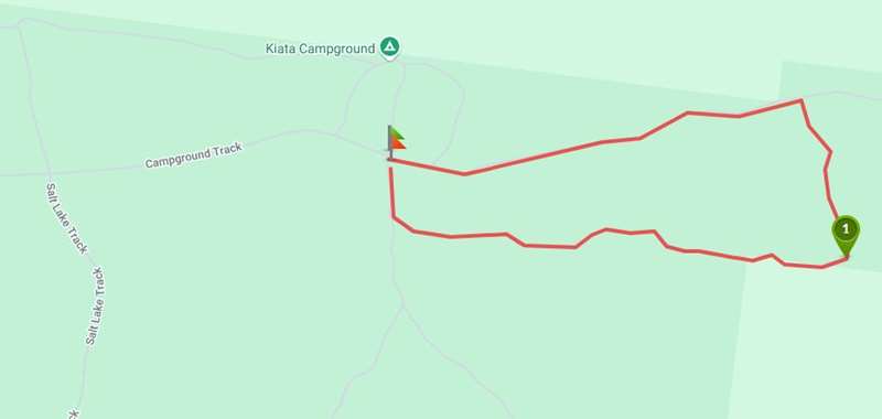
Kiata Camp Ground - Red Gum Loop Walk

Interactive Map
This walk starts at Kiata Campground before turning east onto a sand rise that meanders through brown Stringybark woodland. From here you will cross a channel. The level that the water has reached during periods of rare flooding in this area can be seen by the water marks on the Red Gums. You will then reach the Eucalyptus Distillery Site which closed in 1907. There is an information board at this site. From here the track leads north over a small Banksia-covered dune and back into a Red Gum and Black Box woodland. It is then an easy stroll back to Kiata Campground.
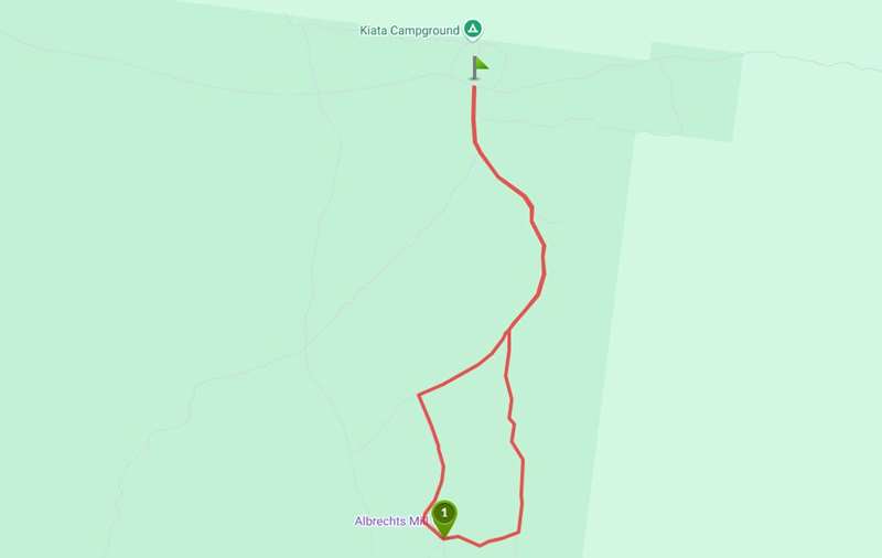
Kiata Camp Ground - Albrechts Mill Walk

Interactive Map
This pleasant walk takes you through a diverse array of vegetation including areas of Silky Tea Tree, Stringybark, tall Broom bush and Mallee. The walk makes its way south-easterly before meeting with the Pump Jack Track. Here you will make your way along the vehicle track until you reach the historic Albrecht's Mill. There is an information board located here. Continue along the walking track that will take you in a northerly direction back to Kiata Campground.
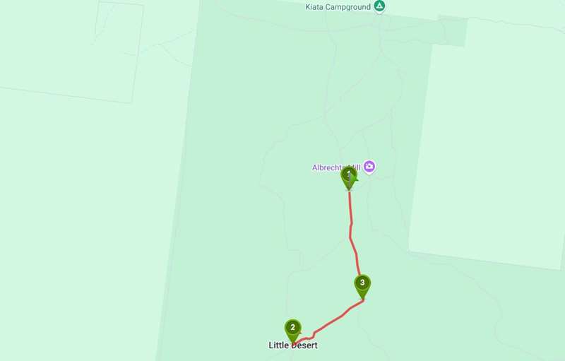
Kiata Camp Ground - Trig Point Walk

Interactive Map
Take this great walk to immerse yourself in the Little Desert. An often-sandy walking track leads off from the Salt Lake vehicle track to a lookout platform offering expansive views across the desert. Accessed via the Kiata Campground access road, the Salt Lake Track is a well-formed gravel track for the first 2.3km. At his point the vehicle track becomes very sandy and only passible by 4WD. It is recommended you park at this junction and walk the extra 2.6km to the lookout. Those with a 4WD and some sand driving experience can continue for another 1.5km to the Trig Point car park. This is a semi-arid desert environment with very little shade, so choose milder weather and carry enough water.
Points of Interest:
1. Salt Lake Track - The Salt Lake Track changes from gravel to sand 2.4km from the Kiata Campground Track. Those without a 4WD can park at the junction and walk the 2.6km ONE WAY to Trig Point.
2. Trig Point Lookout - There is a lookout platform at Trig Point that rises you above the low scrub covering the sand dune, giving you expansive views across the Little Desert National Park.
3. Trig Point car park - 4WD Only. For those who decide to continue driving along the Salt Lake Track, there is a carpark area at the junction where the Trig Point walking track heads off.
Horseshoe Bend/Ackle Bend campgrounds
A short walk that leads to Ackle Bend provides great views of the eastern block, particularly at sunset. Walkers can continue past Ackle Bend and follow the track a further 1km to the river before returning to the campgrounds.
Long distance walks
Desert Discovery Walk
Long distance walkers can tackle all or part of the 84 km Desert Discovery Walk. Options of one to four days duration are possible. A separate brochure is available for this walk. Overnight walkers are asked to register their details in advance at the Park Office. There are two overnight camps along the way, accessible only by walkers. This walk is a great opportunity to experience some of the park's diversity on foot. It is especially colourful in spring
Camping and Accommodation
Basic facilities are provided at park campgrounds south of Kiata, Horseshoe Bend and Ackle Bend, south of Dimboola. Camping fees apply at Ackle Bend and Horseshoe Bend.
Bush camping away from the park campgrounds is permitted in the central and western blocks. A range of accommodation options are available at Kaniva, Nhill, Winiam, Dimboola, Goroke and Natimuk.
Location and Access
Little Desert National Park is 375km northwest of Melbourne. The western and central blocks may be approached from Kaniva, the central and eastern blocks from Nhill or Kiata, and a good gravel road leads to the Wimmera River section of the eastern block from Dimboola. Similarly, bitumen road access is available from the south via Mitre, Gymbowen, Goroke, Edenhope or Booroopki. Once you leave the bitumen, most tracks are very sandy and are suitable for four wheel drive vehicles only.
Note: Photos from Parks Victoria
Location
Little Desert National Park, Dimboola 3414 Map
Web Links
→ Little Desert National Park (Parks Victoria)
→ Little Desert National Park - Park note (PDF)
→ Little Desert National Park - Keith Hateley Nature Walk (PDF)
→ Little Desert National Park - Stringybark and Loop Walks (PDF)
→ Birds of the Mallee Parks (PDF)
→ Little Desert Discovery Walk - Track Notes (PDF)
→ Kiata Camp Ground - Red Gum Loop Walk (Walking Maps)
→ Kiata Camp Ground - Albrechts Mill Walk (Walking Maps)
→ Trig Point Walk, Little Desert NP (Walking Maps)
→ Pomponderoo Hill Walk (Walking Maps)


