Daylesford - Two Lakes Walk

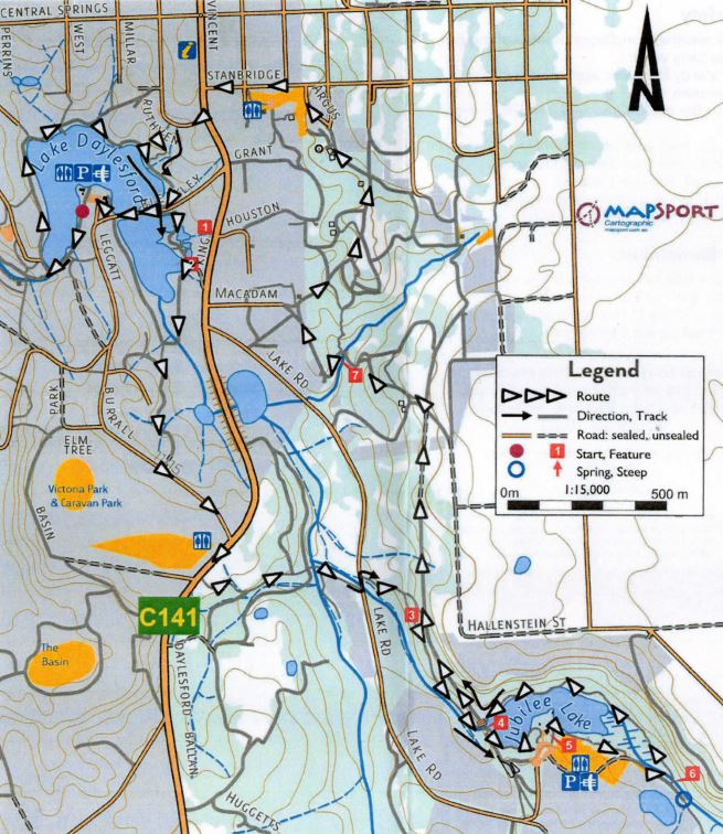
The 8km return Two Lakes Walk connects Lake Daylesford and Jubilee Lake.
Two Lakes Walk Map

From the Visitor Information Centre, drive via King and Bleakley Streets to the car park at Lake Daylesford.
Park your car and walk to the left in a clock-wise direction around Lake Daylesford. Complete the circuit and cross Bleakley Street (bitumen).
Head left along the pathway past the rear of Lake House (1) to the Wombat Flat Springs. (2) Having tasted the water, leave the springs and follow the lake edge to the boardwalk. Follow this to a rough up hill track on your left. Take this track up the hill to Burrall Street (bitumen) and turn left. Continue on to the intersection with Ballan Road and the entrance to Victoria Park. Turn right and walk about 100m along the fence line.
Cross the bitumen road and enter the Jubilee Lake walking track on your left. (3) Follow the main track off Ballan Road to the east. It meanders along through the bush past the sides of private properties until you reach Jubilee Lake Road (bitumen).
Turn left and walk about 30m until you see a GDT/Goldfields Track sign on your right. Follow this track to the old railway/foot-bridge. (4) Cross over the bridge and, keeping left, walk around the lake edge towards the kiosk (5) and camping area. This is a good place for a break.
Follow the path to the kiosk entrance and you will see signs and a track continuing to the right. Follow the lake edge keeping it on your left for about 1km until you reach a wooden footbridge on your left. (6)
Cross the bridge and follow the lake edge in an anti-clockwise direction back to the old railway bridge. At the entrance to the old bridge, turn right and scramble up the steep steps to enter the old railway line.
Follow the railway line to the first intersection. (Note gravel road and Italian Hill sign). This is Patterson Street.
Turn left and walk downhill for about 50m to a GDT sign on your right. Turn right here and follow the track downhill to the Information Board and picnic area. Follow the track uphill, past Macadam Street to Stanbridge Street (bitumen) at the top of the hill.
Turn left into Stanbridge Street and walk down to King Street (the Primary School is directly ahead). Turn left and walk to Ruthven Street where you turn right and walk about 100m to a well made path leading to the lake edge.
Follow this path to the left along the lake edge to Bleakley Street (bitumen). Turn right and walk over the bridge and back to the car park.
Location
2 Leggatt Street, Daylesford 3460 Map


