Daylesford - Jubilee Lake Walk

Jubilee Lake, originally called Hepburn Gold-fields Reservoir, was built in 1860 to supply water to Daylesford and the Hepburn gold-fields. It was renamed Jubilee Lake in 1887 in honour of Queen Victoria's Golden Jubilee. This 4km return, 1.5-2 hr walk covers the Jubilee Lake area.
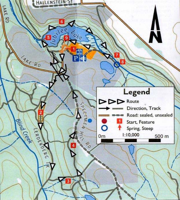
Jubilee Lake Walk Map

Starting from the Daylesford Visitor Information Centre, drive south on King Street for 1km to Lake Jubilee Road. Turn left and drive a further 2km and enter Jubilee Lake Park. (1) Having parked, walk back to the entrance, turn right and walk about 50 paces along Jubilee Lake Road until you see a track on your left and a GDT sign. Cross over and walk down this track which takes you to a dis-mantled railway line. This is part of the former Daylesford-Ballarat line which was closed to passengers in 1951 and dismantled between 1953-86.
Follow this track for about 1km, noting on the way the old railway cutting, (2) until you get to a track on your left marked with a GDT sign. Ignore any other side tracks.
Follow the GDT signs to the top of the hill. The large mullock gill (waste material from a mine shaft) on your right is the dump from the former Old Specimen Hill mine. (3) The Specimen Hill reef was discovered in 1857 and was worked by the Specimen Hill Coy from the mid 1860's to 1880 in which time the company reached a depth of nearly 600 feet for a pay-load of nearly 28,000 ozs of gold. The site is included in the Victorian Heritage List.
At the "T" intersection, turn left and continue on the track for about 250m. Note on your right the mullock hill from the New Specimen Hill mine which ceased operation in 1914 having achieved little success. (4)
Follow the fence line up the hill, ignoring side tracks, until you reach a "T" intersection with Jubilee Lake Road. Turn left and walk a further 500m down this road towards Jubilee Lake. Walk with care as this is a 100kmh road. As you proceed note the old saw mill on your right.
When you again reach the Park entrance, turn right into the Reserve and walk about 100m to a track on your left. Follow this track past a rotunda to some steep steps down to an old railway bridge and weir. (5) Cross the bridge, turn right and follow the track along the side of the ake and Jubilee Creek. You may notice water flowing across the track in several plac-es. This is coming from old gold mine tunnels under Italian Hill on your left. (6)
After you have walked for about 10 minutes, the track crosses Jubilee Creek. Walk across the bridge (7) and turn left. Walk straight ahead for about 100m to the Jubilee Spring. Enjoy the water. (8)
Retrace your steps past the Jubilee Creek bridge and through the avenue of elm trees. Keep to the right and the water's edge. Turn left at the kiosk and return to the carpark.
Location
151 Jubilee Lake Road, Daylesford 3460 View Map


