Churchill - Eel Hole Creek Walking Trail

Discover what the landscape used to be like prior to the development of the Churchill township by wandering along the trail of the Eel Hole Creek on this 4.9km walk.
The township of Churchill was developed in 1965, prior to which large-scale vegetation clearance had occurred and most of the Eel Hole Creek catchment was cultivated for farming. The Creek's headwaters still contains intact indigenous vegetation, while the downstream section is a blend of agricultural and urban land-uses for the rest of the catchment. The artificial wetlands at McDonald Way direct the flow from what used to be a tributary but is now a mainly urbanised zone channelling stormwater flows. Downstream of Northways Road, the artificial wetlands discharge via a culvert and the Eel Hole Creek channel continues its flow into the artificially constructed Lake Hyland. Downstream of the lake, the creek discharges into the Hazelwood pondage.
You will see numerous areas under revegetation, including in the wetland project located behind the Green Inc. building between McDonald Way and Northways Road. The project, co-ordinated by the Federation University's Gippsland Campus, includes the installation of a litter trap at the entry point of the Churchill stormwater drain, the construction of two ponds approximately 90 metres long by 30 metres wide and a filtration pond of 600 square metres, the building of embankments and landscaping of the surrounding area. Further landscaping will enhance the natural setting that, with installation of footpaths, outdoor furniture, lighting, boardwalks and landings, aims to encourage walkers to utilise this area. It is also hoped that the ongoing creation of habitat for birds and animals will lead to an increase in the diversity of plants and animals found along this section of the creek.
This walk is linked to the Churchill township and provides a restful retreat for busy lives. You can access this walk at several points, the main one being via Mathison Park where you head west at the Koori Garden, next to the historic Hare's Farmhouse, instead of returning along the track to Mathison Park's main car park. The trail meanders alongside Eel Hole Creek to the north, crossing Philip Parade, McDonald Way and Northways Road up to Kurnai College's Junior Campus. You can join the trail at any of these crossings. There is an additional reach between Mackeys Road and Tramway Road where you can explore the Eel Hole Creek Reserve.
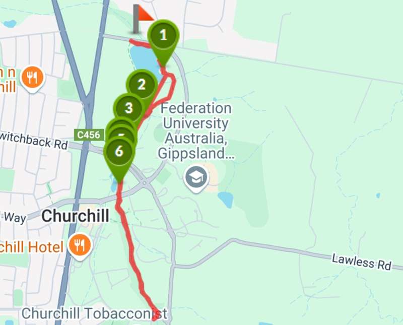
Map of Route
Interactive Map
Points of Interest
1. Grand old tree
Remnant Eucalypts form part of the vegetation, giving you an indication of the forest that used to embrace this creek.
2. Walking over water
No need to get your feet wet as you cross the bridges along the trail.
3. Place for a picnic
Take a hamper and enjoy the grasslands alongside the Eel Hole Creek.
4. Painted Poles
See the beautiful images painted by local school children expressing what they learnt on a field trip connecting the sciences to the arts
5. The wetlands
Cast a fishing line or just enjoy the view on the platform built over the water.
6. Walk or ride
Sections of the trail are user-friendly to walkers and bike-riders alike.
Location
19 Mackeys Road, Churchill 3842 View Map
Web Links
→ Eel Hole Creek Walking Trail (Walking Maps)


")