Castlemaine - Walk to the Botanic Gardens via Kalimna Reserve

A 7.5 km round walk from the Information Centre to the Burke and Wills monument, the Kalimna Bushland and the Castlemaine Botanic Gardens.
Most of the walk is along defined roads and tracks. There are a few steep climbs and some rough sections. The route is not marked with arrows. Route directions are given below. Some bushland tracks are becoming eroded. Wear sturdy footwear, take water, and clothing suitable for the season, and a compass. Water and toilets are available at the Botanic Gardens.
The walk can be shortened if desired. Alternative routes could be a return via Hunter Track and Hunter Street, or along Hargraves Street. With a car shuffle, the walk could terminate at the gardens.
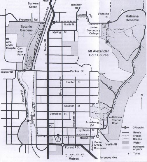
On the walk
[The numbers give the distance in kilometres. 0.01Km = 10m.]0.00 The walk starts in Mostyn Street, outside the Market building, now the Castlemaine Visitor Information Centre.
From the Market building walk eastwards along Mostyn Street.
0.05 The former High School building is on the right. Later, it housed Castlemaine Junior Technical College, and the facade is now part of a supermarket.
Cross Hargraves Street, and continue eastwards. The east end of Mostyn Street is noted for its historic buildings.
0.36 Castlemaine Primary School is at the corner of Urquart Street. An information board is on the west wall of the school.
Continue eastwards up a steep slope to the monument.
0.73 Burke and Wills Monument. Robert O'Hara Burke was sergeant of police at Castlemaine before leading the ill-fated Victorian Exploring Expedition of 1860-61.
From the lookout the churches are, from left to right: Christ Church (Church of England, now Anglican, sandstone), St Andrews (Presbyterian, now Uniting Church, brick), Congregational Church (now Presbyterian, brick), the Church of Christ (now a funeral parlour, iron roof) and St Mary's Church and school (Roman Catholic, white). Other prominent buildings are the Castlemaine Primary School, the Post Office with the clock tower, and the old gaol.
Central Castlemaine is at the junction of two creeks: Forest Creek (east-west) and Barkers Creek (north-south).
Hills in the distance are Mt Consultation (an extinct volcano, slightly south of west) and Mt Tarrengower (west north-west).
From the monument, walk down hill (north) along Wills Street to Lyttleton Street. Turn right (uphill) for 100 metres and turn left into Armstrong Court. On reaching Kalimna Park, take the first turn right (south-eastwards). The track soon turns east, and then north, above the Kalimna Tourist Road.
On reaching the main track we have a detour to Kalimna Point lookout. Turn left, up a slope, for 80 metres, to the band rotunda and Kalimna Point.
1.34 Kalimna Point and Band Rotunda. This part of the reserve was cleared and planted with exotic species and non-local natives. The large Sugar Gums now block much of the view. Over the years, the area has been recolonised by indigenous plants. The band rotunda was repaired as a bicentennial project, organised by the Friends of Kalimna Park.
Turn back down the track (east) to the Kalimna Tourist Road
1.47 Kalimna Tourist Road. Turn left (north) along the road The road passes through the Kalimna bushland.
The Kalimna bushland is an example of heathy dry forest. The plants are adapted to the dry conditions. Adaptations include small leaves, which may have tough, waxy and/or hairy surfaces, to help reduce water loss in summer. The trees drop leaves during summer, and a carpet of fallen leaves is typical of the local forests.
This bushland has not been burnt for very many years and is noted for the diversity of plants. Many shrubs died during the drought years but there was extensive regeneration after several wetter seasons.
1.74 Hunter Track corner. Continue along the main road
1.88 An anticline is exposed in the cutting on the right of the road. It is best seen by looking back (to the south-east). These rocks are made of sediments deposited in a shallow sea about 450 million years ago (in the Ordovician period). After a time, the sediments slipped downhill, in an underwater avalanche, to form new layer about 30cm thick. These layers are separated by a thin layer of fine grained rock formed by the settling of material suspended in the water. Since then, pressure from the east has folded the rocks.
2.23 Crest. This is the highest elevation on the walk, and is just over 360 metres above sea level. The road is along a ridge which separates Barkers Creek to the west and Moonlight Creek to the east. Further east is a larger ridge, which is the boundary between the goldfields' sedimentary rock and the Harcourt granite.
2.68 Circuit Track. Turn left along the Circuit Track. The track at first is in a south-westerly direction. Keep to the main track.
[Originally, this walk took a more direct route to the Vanston St. corner. Parts of the more direct track are now deeply eroded]
2.70 Heathy Dry Forest. These forests are noted by a mixture of eucalypt species, and a wide range of shrubs and herbaceous species. Common eucalypts along the track are Red Stringybark, Grey Box, Long-leaf Box and Red Box. Many of the trees have a mallee-like appearance. When the original trees were cut down, suckers grew from the base. These have now grown into trunks. Wattles include Golden, Gold-dust. Spreading, Hedge and Rough Wattles. Native grasses. lilies, daisies and orchids are also present, and make a show in spring.
Holes have been dug in the reserve by miners searching for gold, by the army in the 1940s, and for rock. The shape of the hole gives an indication of the purpose of the digging.
3.34 Cross tracks, at the base of a hill. Turn right. downhill for 30 metres, to a drain (dug to collect water for a golf course dam). Turn left, following the drain. About 70 metres before reaching the golf course putting green, turn right downhill to a 4WD track.
3.51 4-wheel drive track. The track leads from the golf course to Kalimna Tourist Road. We turn right (north) and follow this track to Kalimna Tourist Road.
There is a maze of tracks in the vicinity. Some were built as a track for driver education. Many of the tracks in Kalimna are now eroded. As water becomes channelled, the erosion rate increases.
3.70 Devonshire Mine was to the left. Recovery after the mining disturbance has been very slow. The mined area is weed infested, and so may never recover to its pre-mining state. Loss of topsoil has reduced fertility, so growth is slow.
3.79 Kalimna Tourist Road. Turn left, past the school.
4.10 Castlemaine Secondary College Junior Campus. Formerly Castlemaine High School. The school was built beside Milkmaid Flat. There are plans to consolidate both junior and senior schools on this site.
The Kalimna Tourist Road becomes Lawson Parade. Continue along Lawson Parade to Blakeley Road.
4.40 Blakeley Road. Turn left along Blakeley Road for about 100 metres to North Street. Turn right (west) along North Street to Barker Street (Midland Highway). Cross the highway opposite the railway pedestrian crossing. Take care crossing the highway and the railway line.
5.00 Melbourne - Echuca Railway. The line was originally a double track to Bendigo, but was reduced to a single line when the line was 'upgraded' in 2005.
Cross Downes Road with care , to the north-east corner of the Botanic Gardens.
5.06 Castlemaine Botanic Gardens. The Botanic Gardens was established in 1860. Many of the trees are labelled. Very large pines are one of the features of the gardens.
Follow the path west and then south beside Barkers Creek.
The gardens extend to the west side of the creek where the bushland is home to a colony of the endangered Eltham Copper Butterfly. Recently, Silver Poplars, Willows and other weeds have been removed from the creek.
5.75 Lake Joanna. The creek has been straightened. Part of the original creek was deepened, and is now Lake Joanna, named after the wife of a former mayor. Another lake. Lake Augusta, which was west of the creek, was filled in and is now a sports field.
Follow the creek to the southern boundary of the gardens. Cross Walker Street, and cross the creek to Gingell Street.
6.14 Gingell St corner. Turn left (south) along Gingell Street.
6.30 Elms are a feature of Gingell Street. Barkers Creek is on the left. Many streams in the goldfields are very degraded, as a result of mining, course alteration and weed infestation. Recently many of the weedy plants have been removed from the creek, as part of a flood control program.
7.00 Footbridge. Just before reaching Camp Reserve, and opposite the Railway Hotel, cross the creek at the bridge, and continue through the subway. From the railway station, follow the track leading at an angle (south-east) up the embankment, to Kennedy Street.
7.10 Archdeacon's Walk was named after Archdeacon Archibald Crawford, who was Rector of the Church of England parish (1859-1884), and who used this path to reach the railway station. He travelled extensively through the district when carrying out his pastoral duties.
7.18 Tertiary Gravels. Water-worn rounded gravels can be seen in the embankment on the east side of Kennedy Street. The gravels were once in the bed of Barkers Creek, which has since cut a deeper channel to the west.
Continue south along Kennedy Street for one block to Mostyn Street. Turn left (east) into Mostyn Street.
7.40 Captain Hepburn plaque is attached to the brick fence of the Anglican Church, south-west of the African War memorial. John Hepburn was one of the first settlers in Victoria following the survey by Major Mitchell. Hepburn settled in the Smeaton District.
Continue along Mostyn Street past Victory Park to the information Centre.
Information provided by Castlemaine Field Naturalists Club
Location
44 Mostyn Street, Castlemaine 3450 Map
")


")