Castlemaine - Forest Creek Trail

Forest Creek Trail is a grade 2, 9km one-way walk which takes 2-3hrs along a well-marked gravel and earth track which is relatively flat with gentle hills. No bushwalking experience is required. After rain, the trail may involve a shallow water crossing where the path crosses Forest Creek. The trail is suitable for some road bikes in dry weather but mountain bikes are recommended (rating: green / easy).
Follow Forest Creek through what was once the richest goldfield in the world on this shared walking and cycling trail from the Western Reserve on Hargraves St in Castlemaine to Expedition Pass Reservoir at Golden Point. Visit the site of the Monster Meeting along the way and take detours to the Pennyweight Flat Cemetery and Forest Creek Gold Diggings.
The trail follows the same route as parts of the (3) Monster Meeting Walk, (4) Pennyweight Flat Cemetery Walk, and Goldfields Track. Follow the red-capped posts (or number (7) at track junctions) and look for interpretive signs dotted along the trail.
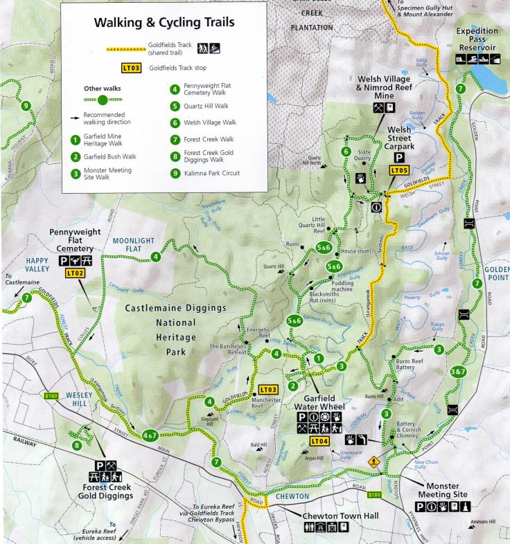
Forest Creek Trail Map
The Forest Creek Trail is labelled (7) on the map.

From the Garfield Trailhead, you can follow the (3) Monster Meeting Walk over Burns Hill then pick up the (7) Forest Creek Trail from the Monster Meeting Site to Expedition Pass (3.7km, 1-1.5hrs) or Castlemaine (3km, 1-1.5hr).
The rush to Forest Creek
The Forest Creek goldrush began in 1852 and lasted less than three years. At its height, thousands of diggers from all over the world would have lived and worked along this creek.
As you walk, look around you and try to imagine what it might have been like, with groups of prospectors working the creek, tents popping up everywhere, children gathering wood or water and people cooking over open fires. Imagine the sounds of thousands of people digging, felling, chopping, hammering, swishing water and soil in pans or cradles, talking and singing in different languages, fires crackling and dogs barking.
A road well-travelled
William Howitt, a noted ethnographer of the time, observed carts travelling from Melbourne to the diggings: "piled with all sorts of diggers' apparatus-shovels, sieves, cradles, iron buckets, picks, axes, and the like. Behind hang whole heaps of pans, panikins, kettles, and iron pots, with a sprinkling of frying-pans. Upon the rest of the cargo lie beds and bedding, and often two or three women and some children. Under or beside the cart go a couple or more of huge dogs."
When Governor Charles La Trobe visited the Mount Alexander Diggings in early December 1851 he was astonished at the number of women and children already on the goldfields.
During 1852-53 when gold fever was at its height, nearly 200,000 men, women and children disembarked in Melbourne, most making their way to the goldfields. By early 1855, women and children represented nearly half of the population on goldfields.
The lucky ones travelled to the goldfields by bullock cart or horseback, but many diggers walked, a journey of days or even weeks on rough tracks, carrying everything they owned.
Expedition Pass Reservoir, a recreational oasis
At the end of the (7) Forest Creek Trail, Expedition Pass is a wonderful place to cool off on a warm day. Enjoy a refreshing swim with family or friends in the cool waters of the reservoir. Fish, paddle, or bring a picnic blanket and relax on the shore.
Dogs are not permitted in the reservoir. The water is deep away from the shore, with submerged obstacles. Please supervise children closely at all times.
There are no facilities and parking is limited, especially on warm weekends and in during school and public holidays, and care should be taken along the busy road. For your own safety, do not park on the roadside. Why not park at the Monster Meeting Site and walk or cycle (7.5km return)?
The reservoir was constructed in 1868 to provide a reliable source of water for the Goldfields community. It takes its name from a gap in the hills named by Major Mitchell on his 1836 expedition. Thousands of diggers travelled through here during the goldrush.
Fed by the surrounding hills and the newly constructed Coliban water race (which also supplied the Garfield Water Wheel), unfortunately the reservoir silted up quickly. After only four years, Castlemaine had to be connected directly to the Coliban Main Channel instead, and by the late 1870s, the reservoir had become a popular oasis for recreational activities.
In 1994, Coliban Water considered decommissioning the reservoir, with one option being to breach the wall and release the water. However, the Mount Alexander Shire stepped in to manage the reservoir until it was added to the Park in 2002.
The forest around the reservoir, which was almost completely cleared during the goldrush, has regenerated significantly, making it a great spot for bushwalking and birdwatching.
Access for Dogs:
Dogs may be walked on a lead on the tracks. They must be kept on a lead and under control at all times. Please collect and remove your dog's droppings for the sake of other visitors and to avoid stress to native animals.
Please note that the Nimrod Reef Mine and Welsh Village is a designated Special Protection Area due to its historic significance, so the (6) Welsh Village Walk is not marked or signed through that area. Dogs and bikes are prohibited. Dogs are not permitted in the Expedition Pass Reservoir.
Safety:
The Castlemaine Diggings are a heavily mined landscape and contain a variety of ongoing hazards, including uneven and unstable ground, mineshafts, open cuts, quarries, and mine tailings. For your own safety, please stay on mapped tracks and supervise children. Comply with local signs and do not climb over or around barriers and fences or on the stone foundations of the water wheel.
Location
Cnr Hargraves Street and Forest Street, Castlemaine 3450 View Map
Web Links
→ Forest Creek Trail Heritage Notes (PDF)


