Boho South - Honeysuckle Headwaters Walk

A 7.1km picturesque walk through open grassy woodland that includes a pretty view of the Honeysuckle Creek valley. Some sections are quite steep, requiring a good fitness level.
Honeysuckle Headwaters Walk comprises a loop of dirt tracks that were probably used in the past by logging machinery and trucks. It follows Honeysuckle Creek Track from Upper Boho Road and returns via Mildrens Track. The Upper Boho Rd section is also dirt, with very little traffic (but be mindful nonetheless). Best on a dry day, it is suitable for able walkers with a good level of fitness.
This is an appealing, moderate length forest wander through open and pretty Peppermint Gum, Yellow and Long Leafed Box grassy woodland. In wetter areas Blue Gums appear. Seasonal wildflowers are also a treat. Due to past logging, trees in this part of Strathbogie State Forest are relatively young, but remnant older large trees with active wildlife hollows can still be found.
You can begin at either the Honeysuckle or Mildrens entrance off Upper Boho Road. You can walk in either direction. However, the more spacious parking opportunities are available at the intersection of Honeysuckle Creek Track and Upper Boho Road. If you want a shorter bush meander with a picnic in the forest, walking or 2WD will take you to a more open picnic area below this entrance, with room for parking. This is also the best way to locate the rural views of the Honeysuckle Creek head waters valley.
Beyond the picnic point is definitely for walking only (unless you have a very capable 4WD and the skills to use it). You will ascend 282m from the bottom. The steeper gradients are encountered as you head up toward Mildrens Track from the Honeysuckle Creek gully. Some sections of the track here are very steep indeed. 4WDs have severely trenched the steepest sections. Consequently, these parts of the track may consist of churned mud. However, walking on firmer ground beside the track is quite possible.
Honeysuckle Headwaters Walk Map
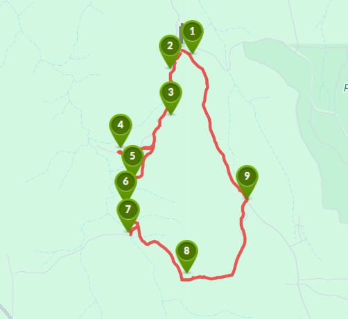
Interactive map
Points of Interest:
1. Strathbogie State Forest sign
Car parking space is available at the entrance to Honeysuckle Creek Track beside the sign on Upper Boho Road.
2. Firewood collection area
The regulations surrounding firewood collection from the forest are clearly described.
3. Forest view
The open grassy woodland lets in enough sun to welcome you with dappled light and many shades of green.
4. View into Honeysuckle Creek Valley
This edge of the forest rural view is as pretty as you could wish for.
5. Open space for a picnic
With enough cleared space to spread out, this is a perfect forest picnic spot for the visitors to enjoy.
6. An enormous Yellow Box
See the tiny red jacket at the base of this majestic tree? This forest may have been logged in the past, but aged survivors can still be found and celebrated.
7. Where the waters gather
Above this narrow gully, this small creek begins its gathering of the waters that run to Violet Town as Honeysuckle Creek. It then goes on to join the distant Goulburn River.
8. Steep slopes
The gradient gets pretty serious here and it isn't just a short climb. Be advised, this ascent is not for the frail or unfit.
9. Mildrens Track
Whether you go clockwise or anti clockwise, this T junction is the other point at which you meet Upper Boho Road.
Access for Dogs:
Dogs are permitted on leash.
Location
James Track and Honeysuckle Creek Track, Boho South 3669 Map
Web Links
→ Honeysuckle Headwaters Walk, Boho South (Walking Maps)
")


")