Ballan Shire Tour of Bicentennial Plaques


The Ballan Road District was proclaimed in the Victorian Gazette on 14th October, 1862. Although the boundaries were loosely defined, these approximated generally with the present boundaries. The first Board consisted of 9 members representing a sub-divided District of 3 divisions,. Eastern, Central and Western, with three, four and two members respectively. So began local government in Ballan.
The Shire of Ballan is one of the fastest growing rural municipalities in Victoria. Until recently the Shire has been predominantly a pastoral grazing area with some cropping - of potatoes and onions particularly - with special emphasis on fat lamb production. For the past few years the Shire has experienced a population growth. New sub-divisions are changing the face of the townships of the Shire, particularly in Ballan, Greendale, Gordon and Egerton areas. The Great Dividing Range is 19km north of the town. Ballan has a Shire Offices, a Post Office, banks, churches, State and Catholic primary schools, Infant Welfare and Pre-School Centre, swimming pool, recreation areas, mineral springs, a hotel, hospital, hostel, CFA, RSL and various other shops, businesses and light industries.
BALLAN
No.1. Ballan-Ballanee, Inglis Street, Ballan
Early in the year 1838, Robert von Stieglitz, in company of Cowie, Stead and two of the Manifolds, set forth from Geelong to explore the upper reaches of the Moorabool River, and on arriving at the present site of Bungeeltap, drew lots for the area. Cowie and Stead were successful, and settled there, calling the property by that name. The two Manifolds withdrew at this point, von Stieglitz then proceeded in a northerly direction and perceiving what appeared to be another river system to the east of the Moorabool, came upon the bed of the Werribee River about one mile upstream from the present Ballan township. Here he selected just under 5,000 acres on the west side of the river, and this he named "Ballan". On the east side of the river his brother John established the "Ballanee" run of 16,000 acres. Two oak trees are now all that remains on the site of Robert von Stieglitz pre-emptive right in Ballan.
NORTH OF BALLAN
No.2. Hunts Weir-Bunding, Dehnerts Road, Bunding
Five Hunt brothers were involved in the construction of the dam. The water was diverted into the Ballan Channel which was constructed in 1900. The channel flowed 37km to Stony Creek near Anakie from where the water was piped to Geelong.
No.3. Spargo Creek, Spargo Creek Road
Spargo Creek was a well known recreation area, with the mineral springs a big attraction. It was a popular picnic area, and many Sunday School and group picnics were held there. Mud scrambles were held in the area in the 1930s.
No.4. Korweinguboora, Ballan-Daylesford Road
Korweinguboora is an Aboriginal word for the sound made by bullfrogs. Sport has always been the important part of the district which has produced many famous axemen. Korweinguboora is a pastoral district that had a store, hotel and school, and was noted for its timber, saw mills and mineral water industry.
No.5. Blakeville, Lilburne Lane
Blakeville was named after Edward Blake, who was known for his timber and sawmilling interests in the district. In the early 1880s he moved house and family to Ballan. He travelled to Australia on the same ship as Peter Lalor of "Eureka" fame.
No.6. Greendale, Greendale-Myrniong Road
Greendale is situated on the southern side of the State Forest. The area is very susceptible to fires. During the gold rush at Blackwood this area of Greendale and Korobeit thrived. Unfortunately, with the termination of the gold, these small towns gradually disappeared, many of the houses, schools, churches being removed or destroyed. The Greendale Church of England, which was to have accommodated 200 people was never completed as the population drifted away. This half-completed church is still standing.
No.7. Blackwood, Recreation Reserve Road
Blackwood is a great tourist district known for its mineral springs and bush scenery. In late 1854 two drovers from Ballan, Harry Athorn and Harry Hider, first discovered gold in the Lerderderg area. At the time the area was inaccessible, and Cobb & Co. started a coach run. In 1858 Blackwood had a population of 13,000 including over 500 Chinese.
EAST OF BALLAN
No.8. Ingliston, Ingliston Road, Ballan
Ingliston was named by Peter Inglis, a pioneer of the district. He was a draper from Glasgow and arrived in Australia in 1840. He was well known in racing circles and owned a number of race horses. The Ingliston homestead and numerous outbuilding are still standing. There was a Railway Siding at Ingliston on the Ballan-Melbourne Line, and a school, both no longer in existence.
SOUTH OF BALLAN
No.9. Pyke, 'Old Cemetery' Ballan-Geelong Road
Pykes Creek Reservoir was named after Thomas Pyke who introduced hunting to the Ballan area. The reservoir is popular for boating and picnics. The plaque is situated near the Pyke family vault at the Old Ballan Cemetery on the Geelong Road.
No.10. Fiskville, Ballan-Geelong Road
Fiskville was named after Sir Ernest Fisk. It was a transmitting station for Overseas Telecommunications between 1927 and 1969. The name was changed to Fiskville in 1933. The site was taken over in 1972 by the Country Fire Authority as a training centre, and now is no longer used by the CFA.
No.11. Beremboke, Recreation Reserve, Blacks Road
Selected in 1839, had a Presbyterian Church, State School No. 1017, Post Office and tennis club. It has always been a farming district, and after World War 2 approximately 1800 acres were divided into three soldier settlement blocks.
No.12. Morrison, Ballan-Meredith Road
Borhoneyghurk and Moreep were taken up in 1837. Hugh Morrison ran Moreep from 1854 to 1866. A gold rush took place at Dolly's Creek in 1856. By the 1860s, Morrisons Diggings had developed into a well established mining town in the valley. At this time, the population numbered 800-900 Europeans and 700 Chinese.
No.13. Ballark, Egerton-Ballark Road
Mount Wallace was named after John Wallace, who was one of the earliest settlers in the district. He lived at Ballark, which was selected by him in 1838. The Molesworth family have occupied the property since 1915. No.14. Bengal, Egerton-Ballark Road Egerton was once a thriving township with many gold mines. Many of the families on the diggings lived in tents. The town had numerous hotels, an undertaker, Churches, Cemetery, Primary School and a Kaolin mine.
No15. Bongeeltap, Egerton-Bungeeltap Road
Dugald MacPherson acquired Bungeeltap West from John Cowie in 1854. The present homestead was built in 1861 from local sandstone. The Emly Park homestead was built in 1840 by David Vere Stead.
WEST OF BALLAN
No.16. Gordon Goldfields, Dicker Street, Gordon
The first gold strike in Gordon was in 1853. By 1859 Gordon had a Post Office, Court House and Barracks. In 1873 the first public school was erected; and then in 1883 the State School No. 755. In 1884 the Catholic School was built; in 1875 St. Patrick's Catholic Church was built. The London Chartered Bank was built in 1876 and is now a private residence.
Alternative location description
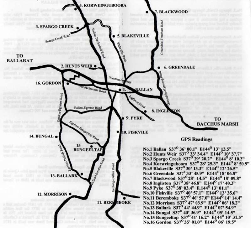
No.1 Ballan -37.600028, 144.220417 (Cnr Bradshaw Street and Inglis Street, Ballan)
No.2 Hunts Weir -37.559556, 144.177139 (Along Dehnerts Road, south of Bolwarrah Weir)No.3 Spargo Creek -37.488944, 144.136167 (Cnr Spargo Creek Road and loop road to Spargo Creek Mineral Spring Reserve, Spargo Creek)
No.4 Korweinguboora -37.473694, 144.147472 (Entrance to Korweinguboora Recreation Reserve, 1399 Ballan-Daylesford Rd, Spargo Creek)
No.5 Blakeville -37.503694, 144.207361 (Along Lilburne lane, Blakeville)
No.6 Greendale -37.562750, 144.301889 (Near 34 Greendale-Myrniong Rd, Greendale)
No.7 Blackwood -37.470694, 144.302722 (Blackwood Sports & Recreation Reserve, 31 Recreation Reserve Rd, Blackwood)
No.8 Ingliston -37.646333, 144.294528 (East of cnr Ingliston Rd and Ingliston-Settlement Rd, Ingliston)
No.9 Pyke Co-ordinates not resolving. Close to -37.633918, 144.216936 (5112 Geelong-Ballan Rd, Ballan)
No.10 Fiskville -37.682528, 144.226556 (Cnr Geelong-Ballan Rd and Plantation Parade, Fiskville)
No.11 Beremboke -37.782500, 144.237333 (Beremboke Public Recreation Reserve, Blacks Rd, Beremboke)
No.12 Morrisons -37.784417, 144.105056 (South of 754 Ballan-Meredith Rd, Morrisons)
No.13 Ballark -37.745806, 144.131917 (Near the Moorabool River East Branch, along Egerton-Ballark Rd, Morrisons)
No.14 Bungal -37.676917, 144.087361 (Egerton-Ballark Rd, 600m south of McFarlanes Lane, Bungal)
No.15 Bungeeltap -37.687833, 144.175417 (Egerton-Bungeeltap rd, east of Moorabool River East Branch)
No.16 Gordon -37.583611, 144.105417 (Dicker St, Gordon)
Information by Ballan Shire Historical Society
Review:
We found these plaques very difficult to locate. Even so, it's a nice drive around a lovely part of the state.


")